IMAGES TAKEN NEAR TO
Jarvis Street, LEICESTER, LE3 5BN
Introduction
This page details the photographs taken nearby to Jarvis Street, LE3 5BN by members of the Geograph project.
The Geograph project started in 2005 with the aim of publishing, organising and preserving representative images for every square kilometre of Great Britain, Ireland and the Isle of Man.

There are currently over 7.5m images from over14,400 individuals and you can help contribute to the project by visiting https://www.geograph.org.uk
Image Map
Images are licensed for reuse under creativecommons.org/licenses/by-sa/2.0
Notes
- Clicking on the map will re-center to the selected point.
- The higher the marker number, the further away the image location is from the centre of the postcode.
Image Listing (609 Images Found)
Images are licensed for reuse under creativecommons.org/licenses/by-sa/2.0
Image
Details
Distance
1
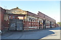
The former Great Central Railway Leicester Central Station
See http://www.gcrleicester.info/html/leicester_central1.html http://www.gcrleicester.info/html/leicester_central.html http://www.disused-stations.org.uk/l/leicester_central/index13.shtml
Image]
Image: © Ashley Dace
Taken: 17 Oct 2010
0.01 miles
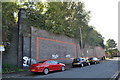
2
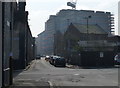
Jarvis Street in Black Friars, Leicester
Image: © Mat Fascione
Taken: 13 Mar 2016
0.02 miles
3
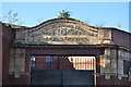
Great Central Railway Parcel Office
The former entrance to the GCR parcel office, now used as a garage.
See Image]
Image: © Ashley Dace
Taken: 17 Oct 2010
0.02 miles
4
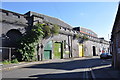
Great Central Railway Viaduct
The large viaduct now supports an industrial estate on the remains of Leicester Central station. A few of the arches are used by car firms as well.
Image: © Ashley Dace
Taken: 17 Oct 2010
0.02 miles
5
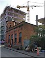
The Great Central generator house, Leicester
This old building stands on the corner of Jarvis Street and Alexander Street in the Black Friars area of Leicester. Alexander Street no longer exists, it has been completely cleared for redevelopment.
The building probably provided power to the former Leicester Central Station, which was located nearby.
Black Friars is an area of the city of Leicester next to the River Soar, it is named after a former Dominican friary. The area is being redeveloped with a mixture of apartments and offices.
Image: © Mat Fascione
Taken: 10 Apr 2020
0.02 miles
6
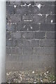
Benchmark on Railway Bridge, All Saints Road
Ordnance Survey cut mark benchmark described on the Bench Mark Database at http://www.bench-marks.org.uk/bm57335
Image: © Roger Templeman
Taken: 22 Apr 2014
0.03 miles
7
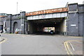
Railway bridge at All Saints Road / Jarvis Street junction
There is an OS benchmark Image on the right hand bridge abutment right of the 'No Waiting' sign pole.
Image: © Roger Templeman
Taken: 22 Apr 2014
0.03 miles
8
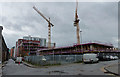
Construction work at Black Friars
At the junction of Jarvis Street and All Saints Road.
Black Friars is an area of the city of Leicester next to the River Soar, it is named after a former Dominican friary. The area is being redeveloped with a mixture of apartments and offices.
Image: © Mat Fascione
Taken: 16 Feb 2020
0.03 miles
9

The former Great Central Railway Leicester Central Station
The old railway station that is now an industrial estate. Image
The canopy and platforms were sited to the left where the units are now. The car park to the right was the site of the turn table.
Image: © Ashley Dace
Taken: 17 Oct 2010
0.03 miles
10
Former Viaduct of the Great Central Railway
This is the remains of the large viaduct that supported the Leicester Central Railway station. The rest (to the right) has been demolished.
Image: © Ashley Dace
Taken: 17 Oct 2010
0.03 miles