IMAGES TAKEN NEAR TO
Thistley Close, LEICESTER, LE3 3RZ
Introduction
This page details the photographs taken nearby to Thistley Close, LE3 3RZ by members of the Geograph project.
The Geograph project started in 2005 with the aim of publishing, organising and preserving representative images for every square kilometre of Great Britain, Ireland and the Isle of Man.

There are currently over 7.5m images from over14,400 individuals and you can help contribute to the project by visiting https://www.geograph.org.uk
Image Map
Images are licensed for reuse under creativecommons.org/licenses/by-sa/2.0
Notes
- Clicking on the map will re-center to the selected point.
- The higher the marker number, the further away the image location is from the centre of the postcode.
Image Listing (22 Images Found)
Images are licensed for reuse under creativecommons.org/licenses/by-sa/2.0
Image
Details
Distance
1
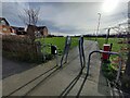
Path next to Goodheart Way, Thorpe Astley
Thorpe Astley is a housing estate and suburb on the western edge of Leicester.
Image: © Mat Fascione
Taken: 20 Feb 2024
0.07 miles
2
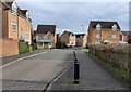
Goodheart Way in Thorpe Astley
Thorpe Astley is a housing estate and suburb on the western edge of Leicester.
Image: © Mat Fascione
Taken: 20 Feb 2024
0.07 miles
3
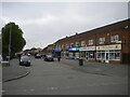
Wardens Walk, Leicester Forest East
Off St Mary's Avenue.
Image: © Richard Vince
Taken: 13 May 2023
0.18 miles
4

Path at Thorpe Astley, Leicester
A housing estate on the western edge of Leicester. On the right is Long Spinney.
Image: © Mat Fascione
Taken: 2 Feb 2017
0.18 miles
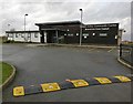
6
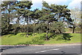
Trees by access to Leicester Forest East Services
Coniferous trees overlooking entrance slip road to services, southbound.
Image: © M J Roscoe
Taken: 24 Mar 2019
0.20 miles
7
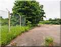
Area of abandoned tarmac at motorway services
The small area of pinkish tarmac is a dreary piece of ground lying to the east of the Leicester Forest East Service Area along the M1. This is perhaps the most attractive view possible; it excludes items of abandoned domestic furniture!
Image: © Trevor Littlewood
Taken: 4 Jun 2018
0.20 miles
8
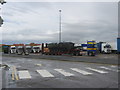
Lorry park at southbound Leicester Forest East Services
Image: © Peter Robinson
Taken: 18 Jul 2012
0.20 miles
9
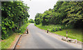
Road leaving Leicester Forest East Service Area
According to OS mapping at 1:25 000, the road leaves Leicester Forest East Service Area (on the east side of the M1) heading north towards an apparently residential area. At the 1:50 000 scale however, the road is just not shown. At higher scales although there's some form of detail shown, there's no suggestion that there's a road on the ground.
Image: © Trevor Littlewood
Taken: 4 Jun 2018
0.20 miles
10
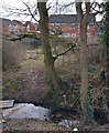
Lubbesthorpe Brook in Braunstone
The houses are on Haskell Close in Thorpe Astley.
Image: © Mat Fascione
Taken: 8 Mar 2017
0.22 miles