IMAGES TAKEN NEAR TO
Sun Way, LEICESTER, LE3 3DS
Introduction
This page details the photographs taken nearby to Sun Way, LE3 3DS by members of the Geograph project.
The Geograph project started in 2005 with the aim of publishing, organising and preserving representative images for every square kilometre of Great Britain, Ireland and the Isle of Man.

There are currently over 7.5m images from over14,400 individuals and you can help contribute to the project by visiting https://www.geograph.org.uk
Image Map (Loading...)


Getting Data...Please wait
Leaflet Map data © OpenStreetMap
Images are licensed for reuse under creativecommons.org/licenses/by-sa/2.0
Notes
- Clicking on the map will re-center to the selected point.
- The higher the marker number, the further away the image location is from the centre of the postcode.
Image Listing (27 Images Found)
Images are licensed for reuse under creativecommons.org/licenses/by-sa/2.0
Image
Details
Distance
1
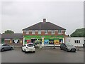
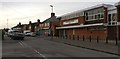
Londis shop, Sun Way, Braunstone, Leicester
Run as franchises; owned by Tescos
Image: © Tim Heaton
Taken: 1 Jun 2022
0.03 miles
2
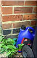
Benchmark on 433 Braunstone Lane
Ordnance Survey cut mark benchmark described on the Bench Mark Database at www.bench-marks.org.uk/bm99543
Image: © phil Richards
Taken: 11 Sep 2018
0.06 miles
4
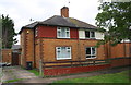
Nos. 433 and 431 Braunstone Lane
There is an OS benchmark Image on the front of the jut on the side of the left hand house, by the wheelie bin
Image: © phil Richards
Taken: 11 Sep 2018
0.06 miles
5
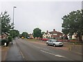
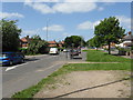
Braunstone Lane, Braunstone Town, Leicester
Image: © Tim Heaton
Taken: 1 Jun 2022
0.11 miles
6
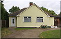
New bungalow on the site of 459 & 457 Braunstone Lane
Ordnance Survey documents show that in 1964 there were two semi-detached dwellings here with outhouses at their rears. The one behind the left hand house had a cut mark benchmark levelled at 95.034m above Newlyn Datum. The outhouses were probably demolished but this was not checked.
Image: © Luke Shaw
Taken: 11 Sep 2018
0.12 miles
7
Braunstone Victoria Working Men's Club
Along Cantrell Road opposite the junction with Bendbow Rise.
Image: © Mat Fascione
Taken: 5 Feb 2020
0.12 miles
8
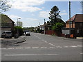
Westover Road
Taken from across Braunstone Lane.
Image: © Peter Whatley
Taken: 7 May 2009
0.14 miles
9
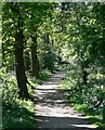
Path through Highway Spinney
A small area of woodland that runs alongside Braunstone Lane. It is surrounded on all sides by housing and busy roads.
Image: © Mat Fascione
Taken: 1 May 2007
0.16 miles
10

#381 Braunstone Lane
There is an OS benchmark Image to the left of the potted plant in the porch
Image: © Roger Templeman
Taken: 11 Sep 2018
0.16 miles