IMAGES TAKEN NEAR TO
Lubbesthorpe Road, LEICESTER, LE3 2XF
Introduction
This page details the photographs taken nearby to Lubbesthorpe Road, LE3 2XF by members of the Geograph project.
The Geograph project started in 2005 with the aim of publishing, organising and preserving representative images for every square kilometre of Great Britain, Ireland and the Isle of Man.

There are currently over 7.5m images from over14,400 individuals and you can help contribute to the project by visiting https://www.geograph.org.uk
Image Map (Loading...)


Getting Data...Please wait
Leaflet Map data © OpenStreetMap
Images are licensed for reuse under creativecommons.org/licenses/by-sa/2.0
Notes
- Clicking on the map will re-center to the selected point.
- The higher the marker number, the further away the image location is from the centre of the postcode.
Image Listing (96 Images Found)
Images are licensed for reuse under creativecommons.org/licenses/by-sa/2.0
Image
Details
Distance
1
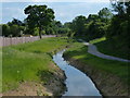
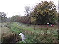
Lubbesthorpe Brook in Braunstone
Lubbesthorpe Brook Flood Alleviation Scheme was completed in September 2013 at a cost of £720,000, the brook was widened and realigned. On the right is a new path running through the Osiers Nature Area.
Compare with Image which is the same view taken 7 months earlier.
Image: © Mat Fascione
Taken: 1 Jun 2014
0.03 miles
3
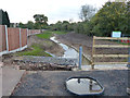
Lubbesthorpe Brook Flood Alleviation Scheme
Construction work has been on going for months, whilst the widening and realigning of Lubbesthorpe Brook takes place.
Image: © Mat Fascione
Taken: 3 Nov 2013
0.05 miles
4
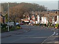
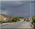
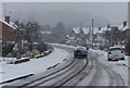
Stormy weather
The junction of Lubbesthorpe Road and Watergate Lane in Braunstone, Leicester.
Image: © Mat Fascione
Taken: 3 Jul 2007
0.05 miles
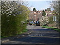
5
Lubbesthorpe Brook and Ossiers Nature Area
Image: © Tim Glover
Taken: 25 Oct 2015
0.05 miles
6
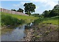
Lubbesthorpe Brook in Braunstone
Lubbesthorpe Brook Flood Alleviation Scheme was completed in September 2013 at a cost of £720,000, the brook was widened and realigned.
The fence on the left runs along the back of houses on Lubbesthorpe Road, the Osiers Nature Area is to the right of the brook.
Image: © Mat Fascione
Taken: 1 Jun 2014
0.05 miles
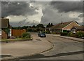
10

New bridge across Lubbesthorpe Brook
Lubbesthorpe Brook Flood Alleviation Scheme was completed in September 2013 at a cost of £720,000, the brook was widened and realigned. This bridge was completely rebuilt and carries Watergate Lane across the brook.
Image: © Mat Fascione
Taken: 1 Jun 2014
0.06 miles