IMAGES TAKEN NEAR TO
Freeboard Road, LEICESTER, LE3 2UN
Introduction
This page details the photographs taken nearby to Freeboard Road, LE3 2UN by members of the Geograph project.
The Geograph project started in 2005 with the aim of publishing, organising and preserving representative images for every square kilometre of Great Britain, Ireland and the Isle of Man.

There are currently over 7.5m images from over14,400 individuals and you can help contribute to the project by visiting https://www.geograph.org.uk
Image Map
Images are licensed for reuse under creativecommons.org/licenses/by-sa/2.0
Notes
- Clicking on the map will re-center to the selected point.
- The higher the marker number, the further away the image location is from the centre of the postcode.
Image Listing (35 Images Found)
Images are licensed for reuse under creativecommons.org/licenses/by-sa/2.0
Image
Details
Distance
1
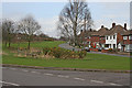
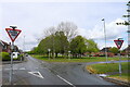
The Kingsway, Braunstone, Leicester
The main residential street through Braunstone with a wide linear "park" along its centre.
Image: © Kate Jewell
Taken: 29 Mar 2006
0.07 miles
3
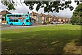
Bus turning onto the Kingsway in Braunstone Town
Image: © Mat Fascione
Taken: 18 Sep 2017
0.13 miles
4
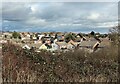
Houses in Braunstone Town
Viewed from the Osiers Nature Area.
Image: © Mat Fascione
Taken: 16 Feb 2024
0.14 miles
5
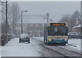
Arriva bus 104 in the snow
Driving along The Chase in Braunstone, with the Winstanley Arms pub in the background.
Image: © Mat Fascione
Taken: 18 Jan 2013
0.15 miles
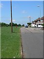
6

Autumn colours along the Kingsway in Braunstone Town
Image: © Mat Fascione
Taken: 6 Nov 2020
0.15 miles
7
The Winstanley public house in Braunstone Town
Everards public house at the Glade in Braunstone Town.
Image: © Mat Fascione
Taken: 15 Feb 2017
0.16 miles
8
Turnbull Drive crossing Kingsway, Braunstone Town, Leicester
"... the striking feature of Braunstone Town is the wide Kingsway, a road which features a large village green at its heart running for the entirety of the street." https://www.secret-bases.co.uk/wiki/Braunstone_Park_%26_Rowley_Fields.
I'm not able to find out why this wide corridor of grass and trees, extending almost a mile from the edge of the Soar floodplain, has not been built on.
Image: © Tim Heaton
Taken: 5 May 2021
0.17 miles
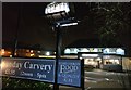
9
The Winstanley Arms, Leicester
Looking along The Chase in Braunstone.
Image: © Mat Fascione
Taken: 22 May 2007
0.17 miles
10
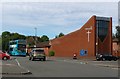
St Crispin's Church in Braunstone Town
On the corner of Turnbull Drive and Edward Avenue.
Image: © Mat Fascione
Taken: 19 Sep 2017
0.17 miles