IMAGES TAKEN NEAR TO
Ravenhurst Road, LEICESTER, LE3 2PS
Introduction
This page details the photographs taken nearby to Ravenhurst Road, LE3 2PS by members of the Geograph project.
The Geograph project started in 2005 with the aim of publishing, organising and preserving representative images for every square kilometre of Great Britain, Ireland and the Isle of Man.

There are currently over 7.5m images from over14,400 individuals and you can help contribute to the project by visiting https://www.geograph.org.uk
Image Map (Loading...)


Getting Data...Please wait
Leaflet Map data © OpenStreetMap
Images are licensed for reuse under creativecommons.org/licenses/by-sa/2.0
Notes
- Clicking on the map will re-center to the selected point.
- The higher the marker number, the further away the image location is from the centre of the postcode.
Image Listing (18 Images Found)
Images are licensed for reuse under creativecommons.org/licenses/by-sa/2.0
Image
Details
Distance
1
Fernhurst Road, Braunstone Town
Off Ravenhurst Road.
Image: © Richard Vince
Taken: 9 Mar 2024
0.06 miles
2
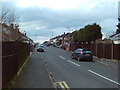
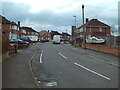
Ravenhurst Road, Braunstone Town
Approaching its junction with Stonehurst Road. It is one of several roads in Leicester's suburbs to retain some concrete road surface at time of visit.
Image: © Richard Vince
Taken: 9 Mar 2024
0.08 miles
3
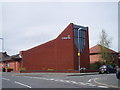
St.Crispin Church
Corner of Edward Avenue, Turnbull Drive.
Image: © tony ellis
Taken: 26 Apr 2008
0.10 miles
4
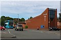
St Crispin's Church in Braunstone Town
On the corner of Turnbull Drive and Edward Avenue.
Image: © Mat Fascione
Taken: 19 Sep 2017
0.11 miles
5
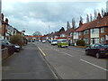
Stonehurst Road, Braunstone Town
Off Ravenhurst Road.
Image: © Richard Vince
Taken: 9 Mar 2024
0.11 miles
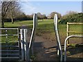
7
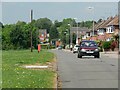
Turnbull Drive crossing Kingsway, Braunstone Town, Leicester
"... the striking feature of Braunstone Town is the wide Kingsway, a road which features a large village green at its heart running for the entirety of the street." https://www.secret-bases.co.uk/wiki/Braunstone_Park_%26_Rowley_Fields.
I'm not able to find out why this wide corridor of grass and trees, extending almost a mile from the edge of the Soar floodplain, has not been built on.
Image: © Tim Heaton
Taken: 5 May 2021
0.15 miles
8
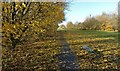
Autumn 2018 in Franklin Park, Braunstone
Image: © Mat Fascione
Taken: 12 Nov 2018
0.19 miles
10
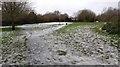
Franklin Park in Braunstone Town
During a brief snowy spell in December 2017.
Image: © Mat Fascione
Taken: 13 Dec 2017
0.19 miles