IMAGES TAKEN NEAR TO
Hazel Drive, LEICESTER, LE3 2JG
Introduction
This page details the photographs taken nearby to Hazel Drive, LE3 2JG by members of the Geograph project.
The Geograph project started in 2005 with the aim of publishing, organising and preserving representative images for every square kilometre of Great Britain, Ireland and the Isle of Man.

There are currently over 7.5m images from over14,400 individuals and you can help contribute to the project by visiting https://www.geograph.org.uk
Image Map
Images are licensed for reuse under creativecommons.org/licenses/by-sa/2.0
Notes
- Clicking on the map will re-center to the selected point.
- The higher the marker number, the further away the image location is from the centre of the postcode.
Image Listing (39 Images Found)
Images are licensed for reuse under creativecommons.org/licenses/by-sa/2.0
Image
Details
Distance
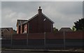
1
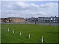
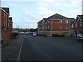
Braunstone-Hazel Drive
Industrial Units looking from Narborough Road South.
Image: © Ian Rob
Taken: 12 Mar 2011
0.03 miles
2
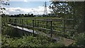
Footbridge crossing the Lubbesthorpe Brook
Image: © Mat Fascione
Taken: 13 Sep 2017
0.09 miles
3
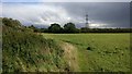
Field on the Aylestone Meadows
This field is next to the Lubbesthorpe Brook and the ASDA superstore at Fosse Park.
The Aylestone Meadows is the largest nature reserve in the city of Leicester, it is situated on the floodplains of the River Soar and River Biam.
Image: © Mat Fascione
Taken: 13 Sep 2017
0.10 miles
4
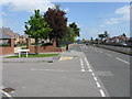
Narborough Road at Bannister Road
On the A5460 dual carriageway in to Leicester (former A46) local access roads are provided either side of the main carriageway, providing access to various residential areas.
Image: © Peter Whatley
Taken: 7 May 2009
0.12 miles
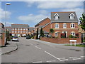
6
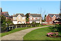
New housing along Narborough Road South
Image: © Mat Fascione
Taken: 23 Nov 2012
0.14 miles
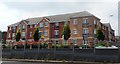
10
Bannister Road
Modern housing immediately off the main A5460 route from the M1 into Leicester city centre.
Image: © Peter Whatley
Taken: 7 May 2009
0.15 miles