IMAGES TAKEN NEAR TO
Hopefield Road, LEICESTER, LE3 2BJ
Introduction
This page details the photographs taken nearby to Hopefield Road, LE3 2BJ by members of the Geograph project.
The Geograph project started in 2005 with the aim of publishing, organising and preserving representative images for every square kilometre of Great Britain, Ireland and the Isle of Man.

There are currently over 7.5m images from over14,400 individuals and you can help contribute to the project by visiting https://www.geograph.org.uk
Image Map
Images are licensed for reuse under creativecommons.org/licenses/by-sa/2.0
Notes
- Clicking on the map will re-center to the selected point.
- The higher the marker number, the further away the image location is from the centre of the postcode.
Image Listing (49 Images Found)
Images are licensed for reuse under creativecommons.org/licenses/by-sa/2.0
Image
Details
Distance
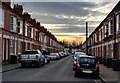
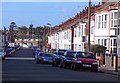
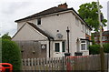
2
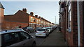
Terraced housing
Terraced housing typical of this area.
Image: © Peter Mackenzie
Taken: 3 Feb 2020
0.02 miles
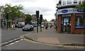
3
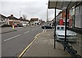
Narborough Road in Leicester
This bus shelter is near the junction with Mountcastle Road.
Image: © Mat Fascione
Taken: 10 Mar 2017
0.04 miles
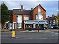
4

Shops along Narborough Road, Leicester
Image: © Mat Fascione
Taken: 19 Dec 2017
0.07 miles
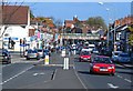
5
Narborough Road (A5460)
Heading north west into Leicester.
Image: © JThomas
Taken: 2 Nov 2013
0.07 miles
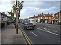
6
The busy Narborough Road
Heading towards Leicester city centre.
Image: © Mat Fascione
Taken: 24 Oct 2008
0.08 miles
8
Pebbledashed semi on Narborough Road
Image: © Roger Templeman
Taken: 11 May 2018
0.09 miles
9
Corner of Danvers Road and Narborough Road
In the Westcotes area of Leicester.
Image: © Mat Fascione
Taken: 5 Jun 2017
0.09 miles