IMAGES TAKEN NEAR TO
Hand Avenue, LEICESTER, LE3 1SN
Introduction
This page details the photographs taken nearby to Hand Avenue, LE3 1SN by members of the Geograph project.
The Geograph project started in 2005 with the aim of publishing, organising and preserving representative images for every square kilometre of Great Britain, Ireland and the Isle of Man.

There are currently over 7.5m images from over14,400 individuals and you can help contribute to the project by visiting https://www.geograph.org.uk
Image Map
Images are licensed for reuse under creativecommons.org/licenses/by-sa/2.0
Notes
- Clicking on the map will re-center to the selected point.
- The higher the marker number, the further away the image location is from the centre of the postcode.
Image Listing (18 Images Found)
Images are licensed for reuse under creativecommons.org/licenses/by-sa/2.0
Image
Details
Distance
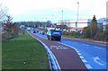
2
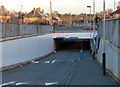
Gallards Hill underpass in Braunstone
The road is passing under the A563 Braunstone Way, Leicester's outer ring road.
Image: © Mat Fascione
Taken: 2 Jan 2015
0.11 miles
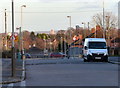
4
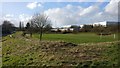
Playing field next to Hockley Farm Road, Leicester
Image: © Mat Fascione
Taken: 15 Feb 2018
0.12 miles
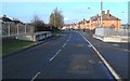
5
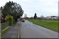
Hockley Farm Road in Braunstone, Leicester
Image: © Mat Fascione
Taken: 16 Jan 2016
0.12 miles
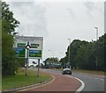
9
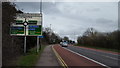
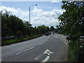
Approaching the Ring Road
The A47 on the approach to Leicester's Ring Road.
Image: © Peter Mackenzie
Taken: 3 Apr 2018
0.17 miles
10
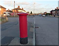
Postbox on Gallards Hill in Braunstone
Near the junction with Heyford Road.
Image: © Mat Fascione
Taken: 2 Jan 2015
0.17 miles