IMAGES TAKEN NEAR TO
Reynolds Place, LEICESTER, LE3 1EU
Introduction
This page details the photographs taken nearby to Reynolds Place, LE3 1EU by members of the Geograph project.
The Geograph project started in 2005 with the aim of publishing, organising and preserving representative images for every square kilometre of Great Britain, Ireland and the Isle of Man.

There are currently over 7.5m images from over14,400 individuals and you can help contribute to the project by visiting https://www.geograph.org.uk
Image Map
Images are licensed for reuse under creativecommons.org/licenses/by-sa/2.0
Notes
- Clicking on the map will re-center to the selected point.
- The higher the marker number, the further away the image location is from the centre of the postcode.
Image Listing (45 Images Found)
Images are licensed for reuse under creativecommons.org/licenses/by-sa/2.0
Image
Details
Distance
1
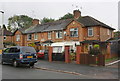
Outside the co-operative store
On Hallam Crescent East in Braunstone Town.
Image: © Mat Fascione
Taken: 24 Jul 2017
0.07 miles
2

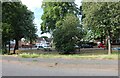
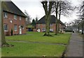
Caldecote Community Primary School
Ordnance Survey documents indicate that in 1964 there was a cut mark benchmark levelled at 72.131m above Newlyn Datum on this school
Image: © Roger Templeman
Taken: 11 Sep 2018
0.11 miles
3
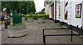
Braunstone Lane, Leicester
Looking towards Hallam Crescent East
Image: © David Howard
Taken: 2 Aug 2022
0.12 miles
6
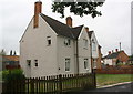
#191 Hallam Crescent East and #111 Waltham Avenue
Ordnance Survey documents indicate that in 1964 there was a cut mark benchmark levelled at 73.344m above Newlyn Datum on the near corner of the left hand house which has been pebbledashed hiding the mark.
Image: © Roger Templeman
Taken: 11 Sep 2018
0.13 miles
7
Nos. 18, 20, 22 and 24 Peverel Road
Ordnance Survey documents indicate that in 1964 there was a cut mark benchmark levelled at 70.046m above Newlyn Datum on the right hand side of the nearest house (#24).
Image: © Roger Templeman
Taken: 11 Sep 2018
0.14 miles
9

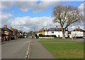
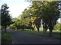
Hallam Crescent East, Braunstone, Leicester
A wide tree lined street in the centre of a radiating 1920's street pattern. As part of a post 1st World War slum clearance programme there was a deliberate policy to give the houses front gardens and set them back from the road ensuring that, unlike the inner-city terraces, there was plenty of light and space. See http://www.le.ac.uk/emoha/community/resources/braunstone/sbraunstone.html
Image: © Kate Jewell
Taken: 21 Feb 2006
0.15 miles