IMAGES TAKEN NEAR TO
Harlaxton Street, LEICESTER, LE3 1DG
Introduction
This page details the photographs taken nearby to Harlaxton Street, LE3 1DG by members of the Geograph project.
The Geograph project started in 2005 with the aim of publishing, organising and preserving representative images for every square kilometre of Great Britain, Ireland and the Isle of Man.

There are currently over 7.5m images from over14,400 individuals and you can help contribute to the project by visiting https://www.geograph.org.uk
Image Map (Loading...)


Getting Data...Please wait
Leaflet Map data © OpenStreetMap
Images are licensed for reuse under creativecommons.org/licenses/by-sa/2.0
Notes
- Clicking on the map will re-center to the selected point.
- The higher the marker number, the further away the image location is from the centre of the postcode.
Image Listing (49 Images Found)
Images are licensed for reuse under creativecommons.org/licenses/by-sa/2.0
Image
Details
Distance
1
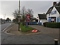
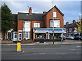
KFC on Narborough Road
The KFC and the U-DIY Centre are in the Old Braunstone Inn.
Image: © Mat Fascione
Taken: 27 Jan 2017
0.06 miles
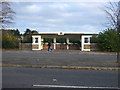
2
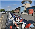
Santander Cycles Leicester
Santander Cycles Leicester is the newest and largest docked e-bike scheme in the UK. It will feature 500 e-bikes at 50 docking stations placed in key locations within the city centre.
This docking station is on Fullhurst Avenue, outside the Merridale Medical Centre.
Image: © Mat Fascione
Taken: 14 Sep 2022
0.06 miles
4
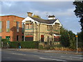
#332 Narborough Road
Ordnance Survey records indicate that in 1964 there was a cut mark benchmark levelled at 71.509m above Newlyn Datum on the left hand side of the building about 7 feet from its front corner.
Image: © Roger Templeman
Taken: 11 Sep 2018
0.08 miles
5
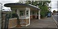
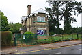
Former art deco tram stop on Narborough Road
This art deco structure was donated to the city in 1934 by hosiery magnate Robert Rowley. It was one of five the businessman had built for tram passengers.
Image
Image
Image
Image
Image: © Mat Fascione
Taken: 24 Oct 2017
0.08 miles
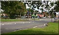
7
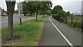
Cycle path along Fullhurst Avenue in Braunstone
On the left is the junction with Gooding Avenue.
Image: © Mat Fascione
Taken: 6 Jul 2017
0.10 miles
8
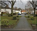
Gaddesby Avenue in the West End area of Leicester
Image: © Mat Fascione
Taken: 10 Jan 2017
0.10 miles
10
Fullhurst Avenue in Braunstone, Leicester
Looking towards the Roxy Chippy on the corner of Fosse Road South.
Image: © Mat Fascione
Taken: 25 Sep 2019
0.10 miles