IMAGES TAKEN NEAR TO
Upperton Road, LEICESTER, LE3 0DZ
Introduction
This page details the photographs taken nearby to Upperton Road, LE3 0DZ by members of the Geograph project.
The Geograph project started in 2005 with the aim of publishing, organising and preserving representative images for every square kilometre of Great Britain, Ireland and the Isle of Man.

There are currently over 7.5m images from over14,400 individuals and you can help contribute to the project by visiting https://www.geograph.org.uk
Image Map
Images are licensed for reuse under creativecommons.org/licenses/by-sa/2.0
Notes
- Clicking on the map will re-center to the selected point.
- The higher the marker number, the further away the image location is from the centre of the postcode.
Image Listing (203 Images Found)
Images are licensed for reuse under creativecommons.org/licenses/by-sa/2.0
Image
Details
Distance
1
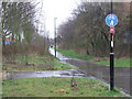
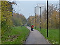
Great Central Way, Leicester
The Great Central Way is a shared footpath and cycle route, following a section of the route of the former Great Central Railway. The Railway was the last main line railway to be built in the Victorian era, opening in 1899. It ran from London's Marylebone station through Leicester and Nottingham to Sheffield and Manchester. The line closed in 1969.
The red sign with the number 6 signifies that this forms part of National Cycle Network route 6. Route 6 links London with Keswick in the Lake District. It is part of a national network of cycle routes mainly using quiet roads and traffic-free paths. Former railway lines make good cycle routes since they generally don't have steep gradients.
Image: © Malc McDonald
Taken: 27 Feb 2011
0.01 miles
2

Lidl store on Upperton Road, Leicester
Image: © Mat Fascione
Taken: 20 Jan 2017
0.01 miles
3
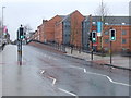
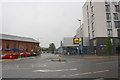
Upperton Road, Leicester
Here, the Great Central Way crosses Upperton Road at a pelican crossing. The Great Central Way follows the course of a former railway.
Upperton Road used to cross the railway on a viaduct here. The viaduct was demolished in 2007, as it was in poor condition, and the road was lowered to ground level. This may explain why the pavement on the opposite side of the road rises, as if to cross a bridge, then falls. There is more information about the Upperton Road Viaduct, and photos taken before and during demolition, at the GCRLeicester website http://www.gcrleicester.info/html/leicester_demolition_2.html
Image: © Malc McDonald
Taken: 27 Feb 2011
0.01 miles
4
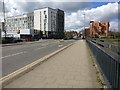
Looking west along Upperton Road, Leicester.
Image: © Mat Fascione
Taken: 1 Apr 2007
0.01 miles
6
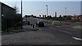
Entrance to carpark from Upperton Road, between LiDL and Starbucks
There used to be a bridge over railway lines at this location. Ordnance Survey records indicate that in 1965 a benchmark levelled at 63.847m above Newlyn Datum existed on the bridge parapet.
Image: © Roger Templeman
Taken: 11 Sep 2018
0.02 miles
7
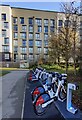
Santander Cycles Leicester
Santander Cycles Leicester is the newest and largest docked e-bike scheme in the UK. It will feature 500 e-bikes at 50 docking stations placed in key locations within the city centre.
This docking station is on Upperton Road.
Image: © Mat Fascione
Taken: 2 Dec 2021
0.02 miles
8
Great Central Way approaching Upperton Road
The large building is the Code student accommodation.
Image: © Mat Fascione
Taken: 19 Nov 2014
0.03 miles
9

Scrap Coaches.
This photo was taken at the scrap yard of Vic.Berry Ltd. It shows clearly the enormous number of coaches that were being scrapped by British Railways during the run up to Privatisation of the railways. Several of these stacks could be seen around the yard.
Image: © Clive Warneford
Taken: 15 Aug 1990
0.03 miles
10

Gangway ends!
The view shows at least 28 coaches stacked waiting for the cutters torch. ref.imageImage
Image: © Clive Warneford
Taken: Unknown
0.03 miles