IMAGES TAKEN NEAR TO
Kings Lock Close, LEICESTER, LE2 9GW
Introduction
This page details the photographs taken nearby to Kings Lock Close, LE2 9GW by members of the Geograph project.
The Geograph project started in 2005 with the aim of publishing, organising and preserving representative images for every square kilometre of Great Britain, Ireland and the Isle of Man.

There are currently over 7.5m images from over14,400 individuals and you can help contribute to the project by visiting https://www.geograph.org.uk
Image Map
Images are licensed for reuse under creativecommons.org/licenses/by-sa/2.0
Notes
- Clicking on the map will re-center to the selected point.
- The higher the marker number, the further away the image location is from the centre of the postcode.
Image Listing (67 Images Found)
Images are licensed for reuse under creativecommons.org/licenses/by-sa/2.0
Image
Details
Distance
1
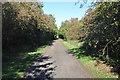
Great Central Way
This is the ex Great Central mainline from Manchester Piccadilly station
to London Marylebone station via Sheffield, Nottingham and Leicester. http://en.wikipedia.org/wiki/Great_Central_Main_Line
Now a footpath into Leicester.
Image: © Ashley Dace
Taken: 20 Oct 2010
0.07 miles
2
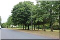
Gilmorton Avenue, Glen Parva
The park is along the Grand Union Canal.
Image: © David Howard
Taken: 2 Aug 2022
0.09 miles
3
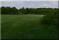
Field next to the Soar Valley Way
The busy Soar Valley Way is in the background, and the Great Central Way footpath is to the right of the view.
Image: © Mat Fascione
Taken: 21 May 2011
0.09 miles
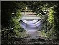
4
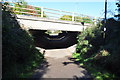
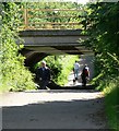
Path under the A563
This is the ex Great Central mainline from Manchester Piccadilly station
to London Marylebone station via Sheffield, Nottingham and Leicester. http://en.wikipedia.org/wiki/Great_Central_Main_Line
Now a footpath into Leicester.
Image: © Ashley Dace
Taken: 20 Oct 2010
0.11 miles
5
The Great Central Way
At this point the footpath/cycleway passes under the busy Soar Valley Way.
Image: © Mat Fascione
Taken: 7 Jul 2007
0.12 miles
6
Underneath Soar Valley Way
The Great Central Way footpath and cycleway passes beneath the busy Soar Valley Way.
Image: © Mat Fascione
Taken: 21 May 2011
0.12 miles
7
A563 Soar Valley Way
Part of the outer ring road of the city of Leicester.
Image: © Mat Fascione
Taken: 13 Apr 2020
0.12 miles
8
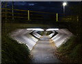
Underpass and the Soar Valley Way
The Great Central Way footpath and cycleway passes beneath the busy Soar Valley Way.
Image: © Mat Fascione
Taken: 3 Dec 2017
0.12 miles
9
Underpass beneath Soar Valley Way
The Great Central Way is a footpath/cycle route that follows a section of the former Great Central Railway, the line closed in 1969.
Image: © Mat Fascione
Taken: 2 Nov 2021
0.12 miles
10
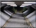
Underpass beneath Soar Valley Way
The Great Central Way is a footpath/cycle route that follows a section of the former Great Central Railway, the line closed in 1969.
Image: © Mat Fascione
Taken: 2 Nov 2021
0.12 miles