IMAGES TAKEN NEAR TO
Burgess Road, LEICESTER, LE2 8QL
Introduction
This page details the photographs taken nearby to Burgess Road, LE2 8QL by members of the Geograph project.
The Geograph project started in 2005 with the aim of publishing, organising and preserving representative images for every square kilometre of Great Britain, Ireland and the Isle of Man.

There are currently over 7.5m images from over14,400 individuals and you can help contribute to the project by visiting https://www.geograph.org.uk
Image Map
Images are licensed for reuse under creativecommons.org/licenses/by-sa/2.0
Notes
- Clicking on the map will re-center to the selected point.
- The higher the marker number, the further away the image location is from the centre of the postcode.
Image Listing (56 Images Found)
Images are licensed for reuse under creativecommons.org/licenses/by-sa/2.0
Image
Details
Distance
1
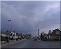
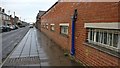
Burgess Road in Aylestone
A typical road of the area, a mix of housing and light industry.
Image: © Mat Fascione
Taken: 31 Jan 2017
0.01 miles
3
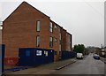
Construction work on Burgess Road, Aylestone
Image: © Mat Fascione
Taken: 31 Jan 2017
0.04 miles
4
Vaughan Road, Aylestone
This lovely building is at the corner of Vaughan Road and St Andrews Road.
Image: © Mat Fascione
Taken: 3 Jun 2007
0.06 miles
5
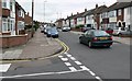
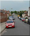
Milligan Road.
This is the junction of Burgess Road and Milligan Road in Aylestone, Leicester.
Image: © Mat Fascione
Taken: 3 Apr 2007
0.09 miles
6
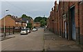
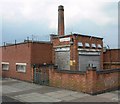
Factory on Vaughan Road
In the Aylestone Park suburb of Leicester, a typical mix of light industry and housing for this area of the city.
Image: © Mat Fascione
Taken: 19 Aug 2017
0.10 miles
7
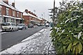
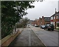
Milligan Road in Aylestone Park, Leicester
During a brief snowy spell in December 2017.
Image: © Mat Fascione
Taken: 11 Dec 2017
0.10 miles
8
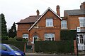
Milligan House, 255 Milligan Road, Leicester
"An excellent representative of a late 19th century rural dwelling house that subsequently lost its rural setting as the city expanded during the Victorian era. Built circa 1880 [date stone above door], the property [has a] high architectural quality with diaper brickwork, vertical hanging tiles and clay peg tiled roof." [Local Heritage Asset Register, Leicester City Council]
Image: © Tim Heaton
Taken: 18 Oct 2021
0.12 miles