IMAGES TAKEN NEAR TO
Dragonfly Walk, LEICESTER, LE2 8DX
Introduction
This page details the photographs taken nearby to Dragonfly Walk, LE2 8DX by members of the Geograph project.
The Geograph project started in 2005 with the aim of publishing, organising and preserving representative images for every square kilometre of Great Britain, Ireland and the Isle of Man.

There are currently over 7.5m images from over14,400 individuals and you can help contribute to the project by visiting https://www.geograph.org.uk
Image Map
Images are licensed for reuse under creativecommons.org/licenses/by-sa/2.0
Notes
- Clicking on the map will re-center to the selected point.
- The higher the marker number, the further away the image location is from the centre of the postcode.
Image Listing (227 Images Found)
Images are licensed for reuse under creativecommons.org/licenses/by-sa/2.0
Image
Details
Distance
1
Aldi Park next to the Grand Union Canal in Aylestone
Image: © Mat Fascione
Taken: 9 Sep 2017
0.01 miles
2
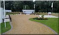
Sales Information Centre
For a new housing development called Otter's Bank, which is under construction. Compare with Image which was taken 32 months earlier.
Image: © Mat Fascione
Taken: 5 Sep 2010
0.01 miles
3
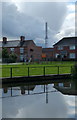
Grand Union Canal in Aylestone, Leicester
Image: © Mat Fascione
Taken: 28 Jun 2017
0.01 miles
4
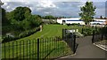
Aldi Park in Aylestone
The playground is next to an Aldi Supermarket and the River Soar. The houses are along Dragonfly Walk, part of a small housing estate called Otters Bank.
Image: © Mat Fascione
Taken: 11 Feb 2017
0.02 miles
5
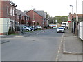
Disraeli Street in Aylestone
The houses are part of a new development called Otter's Bank.
Image: © Mat Fascione
Taken: 15 Apr 2012
0.02 miles
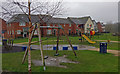
6
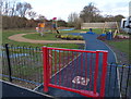
New play area along Granby Road
Built as part of the new Otters Bank housing development.
Image: © Mat Fascione
Taken: 22 Dec 2013
0.02 miles
7
Dragonfly Walk in Aylestone, Leicester
Part of a small housing estate called Otter's Bank, built next to the Grand Union Canal. The white building is an Aldi supermarket on Aylestone Road.
Image: © Mat Fascione
Taken: 3 Jun 2017
0.02 miles
8
Houses at Otters Bank in Aylestone
The reddish sky was caused by the remnants of Hurricane Ophelia dragging in tropical air and dust from the Sahara, debris from forest fires in Portugal and Spain was also playing a part. The dust has caused shorter wavelength blue light to be scattered, making it appear red.
Image: © Mat Fascione
Taken: 16 Oct 2017
0.02 miles
9
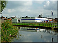
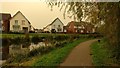
River Soar near Aylestone Park in Leicester
Looking downstream. The smart building is an Aldi supermarket.
Image: © Roger Kidd
Taken: 25 Aug 2013
0.02 miles
10
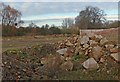
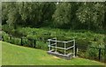
Derelict industrial site
Located at the corner of Disraeli Street and Granby Road in Aylestone. A large factory used to occupy this site before being demolished a couple of years ago.
Image: © Mat Fascione
Taken: 6 Jan 2008
0.02 miles