IMAGES TAKEN NEAR TO
Richmond Close, LEICESTER, LE2 8AY
Introduction
This page details the photographs taken nearby to Richmond Close, LE2 8AY by members of the Geograph project.
The Geograph project started in 2005 with the aim of publishing, organising and preserving representative images for every square kilometre of Great Britain, Ireland and the Isle of Man.

There are currently over 7.5m images from over14,400 individuals and you can help contribute to the project by visiting https://www.geograph.org.uk
Image Map
Images are licensed for reuse under creativecommons.org/licenses/by-sa/2.0
Notes
- Clicking on the map will re-center to the selected point.
- The higher the marker number, the further away the image location is from the centre of the postcode.
Image Listing (159 Images Found)
Images are licensed for reuse under creativecommons.org/licenses/by-sa/2.0
Image
Details
Distance
1

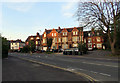
Church of the Nativity, corner of Cavendish and Richmond Roads, Leicester
"A good example of a late 19th century Primitive Methodist chapel ... with a strong visual presence within the street scene ... The chapel was built circa 1883 to the designs of the architect John Wills ..." [Local Heritage Asset Register, Leicester City Council]
Image: © Tim Heaton
Taken: 18 Oct 2021
0.03 miles
2
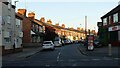
Evening sunshine on Cavendish Road, Leicester
Image: © Ruth Sharville
Taken: 3 Sep 2023
0.06 miles
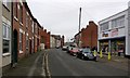
3
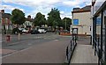
Junction of Cavendish Road and Aylestone Road, Leicester
Image: © Mat Fascione
Taken: 13 Aug 2017
0.06 miles
4
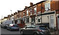
Prince of Punjab Pub & Grill
On Cavendish Road in the Aylestone Park area of Leicester. It was previously known as The Avenue public house, which was closed down in April 2014. A plaque on the front of the building says: Avenue House 1876.
Image: © Mat Fascione
Taken: 26 May 2020
0.06 miles
5

Benchmark on corner wall pier outside #337 Aylestone Road
Ordnance Survey cut mark benchmark described on the Bench Mark Database at www.bench-marks.org.uk/bm88713
Image: © Roger Templeman
Taken: 13 Sep 2017
0.09 miles
6
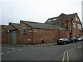
Leicester-Lothair Road
Old industrial premises on the corner of Brooksby Street.
Image: © Ian Rob
Taken: 19 Nov 2011
0.09 miles
7

River Soar in Aylestone
Taken looking east from the tow path of the Grand Union Canal/River Soar in Aylestone. This small offshoot of the River Soar loops back round and forms 'Goose Island'.
Image: © Mat Fascione
Taken: 25 Mar 2007
0.10 miles
8
Aylestone Road towards Leicester
The road is the A426 to Lutterworth and Rugby.
Image: © Andrew Tatlow
Taken: 8 May 2016
0.10 miles
9
Cavendish Road in Aylestone Park, Leicester
Image: © Mat Fascione
Taken: 21 Jan 2017
0.10 miles
10

Aylestone Road houses at Rutland Avenue junction
There is an Ordnance Survey benchmark Image on the right hand face of the stone wall pier on the corner.
Image: © Roger Templeman
Taken: 13 Sep 2017
0.10 miles