IMAGES TAKEN NEAR TO
Cavendish Road, LEICESTER, LE2 7PL
Introduction
This page details the photographs taken nearby to Cavendish Road, LE2 7PL by members of the Geograph project.
The Geograph project started in 2005 with the aim of publishing, organising and preserving representative images for every square kilometre of Great Britain, Ireland and the Isle of Man.

There are currently over 7.5m images from over14,400 individuals and you can help contribute to the project by visiting https://www.geograph.org.uk
Image Map
Images are licensed for reuse under creativecommons.org/licenses/by-sa/2.0
Notes
- Clicking on the map will re-center to the selected point.
- The higher the marker number, the further away the image location is from the centre of the postcode.
Image Listing (132 Images Found)
Images are licensed for reuse under creativecommons.org/licenses/by-sa/2.0
Image
Details
Distance
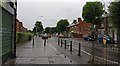
1
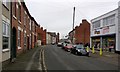
Cavendish Road in Aylestone Park, Leicester
Image: © Mat Fascione
Taken: 21 Jan 2017
0.02 miles
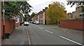
2
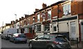
Prince of Punjab Pub & Grill
On Cavendish Road in the Aylestone Park area of Leicester. It was previously known as The Avenue public house, which was closed down in April 2014. A plaque on the front of the building says: Avenue House 1876.
Image: © Mat Fascione
Taken: 26 May 2020
0.02 miles
3

Church of the Nativity, corner of Cavendish and Richmond Roads, Leicester
"A good example of a late 19th century Primitive Methodist chapel ... with a strong visual presence within the street scene ... The chapel was built circa 1883 to the designs of the architect John Wills ..." [Local Heritage Asset Register, Leicester City Council]
Image: © Tim Heaton
Taken: 18 Oct 2021
0.07 miles
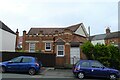
4
Former "Free Public Library, Aylestone Branch", Leicester
"A good example of a late 19th century ... free public library, built circa 1896 ... The library is one of several late-Victorian free libraries built to provide educational facilities for the local residents, following the areas development in the latter half of the 19th century." [Local Heritage Asset Register, Leicester City Council]
Image: © Tim Heaton
Taken: 18 Oct 2021
0.08 miles
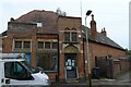
5
Former Police and Fire Station, Aylestone Road, Leicester
A good example of a late-19th century suburban fire and police station ... built
circa 1896. The pair of buildings provided much needed local services to the residents of the area [following its] development in the latter half of the 19th century." [Local Heritage Asset Register, Leicester City Council]
Image: © Tim Heaton
Taken: 18 Oct 2021
0.08 miles
8
Santander Cycles Leicester
Santander Cycles Leicester is the newest and largest docked e-bike scheme in the UK. It will feature 500 e-bikes at 50 docking stations placed in key locations within the city centre. This docking station is along Saffron Lane.
Image: © Mat Fascione
Taken: 6 Dec 2022
0.10 miles
9
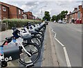
Santander Cycles Leicester
Santander Cycles Leicester is one of the largest docked e-bike schemes in the UK. It will feature 500 e-bikes at 50 docking stations placed in key locations within the city centre and suburbs. This docking station is on Saffron Lane.
Image: © Mat Fascione
Taken: 27 Jul 2022
0.11 miles
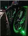
10
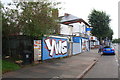
Graffiti on wall on east side of Saffron Lane north of Shakespeare Street junction
Ordnance Survey documents indicate that in 1965 a benchmark levelled at 59.387m above Newlyn Datum was verified on the near end of the wall with the YWS graffiti.
Image: © Roger Templeman
Taken: 13 Sep 2017
0.11 miles