IMAGES TAKEN NEAR TO
Asplin Road, LEICESTER, LE2 6NA
Introduction
This page details the photographs taken nearby to Asplin Road, LE2 6NA by members of the Geograph project.
The Geograph project started in 2005 with the aim of publishing, organising and preserving representative images for every square kilometre of Great Britain, Ireland and the Isle of Man.

There are currently over 7.5m images from over14,400 individuals and you can help contribute to the project by visiting https://www.geograph.org.uk
Image Map
Images are licensed for reuse under creativecommons.org/licenses/by-sa/2.0
Notes
- Clicking on the map will re-center to the selected point.
- The higher the marker number, the further away the image location is from the centre of the postcode.
Image Listing (27 Images Found)
Images are licensed for reuse under creativecommons.org/licenses/by-sa/2.0
Image
Details
Distance
1

Elston Fields
Popular Recreation Ground dominating the centre of this square
Image: © Chris Shaw
Taken: Unknown
0.02 miles
2
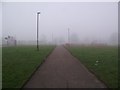
Path through Elston Fields Recreation Ground
Image: © Tim Glover
Taken: 13 Mar 2016
0.12 miles
3

Elston Fields, Saffron Lane estate, Leicester
Aka Tick Tock Park
Image: © Tim Heaton
Taken: 18 Oct 2021
0.12 miles
4
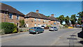
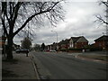
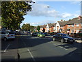
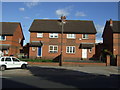
Arnesby Crescent, Leicester
Local authority housing typical of this area of Leicester.
Image: © Peter Mackenzie
Taken: 25 Jun 2018
0.13 miles


8
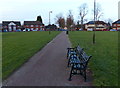
Seats and path on Elston Fields Recreation Ground
Image: © Mat Fascione
Taken: 16 Feb 2014
0.15 miles