IMAGES TAKEN NEAR TO
Wren Close, LEICESTER, LE2 6LX
Introduction
This page details the photographs taken nearby to Wren Close, LE2 6LX by members of the Geograph project.
The Geograph project started in 2005 with the aim of publishing, organising and preserving representative images for every square kilometre of Great Britain, Ireland and the Isle of Man.

There are currently over 7.5m images from over14,400 individuals and you can help contribute to the project by visiting https://www.geograph.org.uk
Image Map
Images are licensed for reuse under creativecommons.org/licenses/by-sa/2.0
Notes
- Clicking on the map will re-center to the selected point.
- The higher the marker number, the further away the image location is from the centre of the postcode.
Image Listing (171 Images Found)
Images are licensed for reuse under creativecommons.org/licenses/by-sa/2.0
Image
Details
Distance
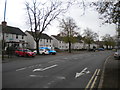
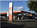
1

Saffron Lane in Aylestone Park, Leicester
Image: © Mat Fascione
Taken: 10 Dec 2017
0.04 miles
3
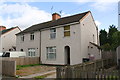
Nos. 378 and 380 Saffron Lane
Ordnance Survey documents indicate that in 1965 a benchmark levelled at 63.365m above Newlyn Datum was verified on the right hand house at its near corner, left hand face. It appears likely that the pebbledash will have covered the mark.
Image: © Roger Templeman
Taken: 13 Sep 2017
0.05 miles
4
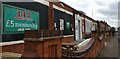
147 Snooker Centre
On Percy Street in the Aylestone Park area of Leicester. It opened in 2017.
Image: © Mat Fascione
Taken: 10 Jun 2017
0.05 miles

8
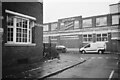
Lifeguard Factory on Grace Road
The corner of Kempson road and Grace road in Aylestone, Leicester. You can see the old Lifeguard children's knitwear company building across the road. Lifeguard went out of business around 1999 and this factory is currently used by Paul James knitwear, since at least 2015.
Image: © Pierre Marshall
Taken: 6 Feb 2021
0.09 miles
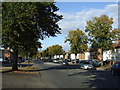
9
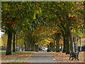
Path at the Aylestone Recreation Ground
This path runs along the south edge of the recreation ground, next to Copinger Road.
Image: © Mat Fascione
Taken: 3 Nov 2016
0.09 miles
10
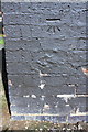
Benchmark on electricity substation, Copinger Road
Ordnance Survey cut mark benchmark described on the Bench Mark Database at www.bench-marks.org.uk/bm88833
Image: © Roger Templeman
Taken: 13 Sep 2017
0.10 miles