IMAGES TAKEN NEAR TO
Knighton Lane East, LEICESTER, LE2 6LU
Introduction
This page details the photographs taken nearby to Knighton Lane East, LE2 6LU by members of the Geograph project.
The Geograph project started in 2005 with the aim of publishing, organising and preserving representative images for every square kilometre of Great Britain, Ireland and the Isle of Man.

There are currently over 7.5m images from over14,400 individuals and you can help contribute to the project by visiting https://www.geograph.org.uk
Image Map
Images are licensed for reuse under creativecommons.org/licenses/by-sa/2.0
Notes
- Clicking on the map will re-center to the selected point.
- The higher the marker number, the further away the image location is from the centre of the postcode.
Image Listing (107 Images Found)
Images are licensed for reuse under creativecommons.org/licenses/by-sa/2.0
Image
Details
Distance
1
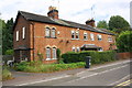
Row of four houses on NE side of Knighton Lane East
There is an Ordnance Survey benchmark Image on the front of the left hand house under its house number (252) and left of the black downpipe
Image: © Roger Templeman
Taken: 13 Sep 2017
0.01 miles
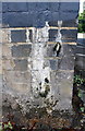
2
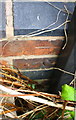
Benchmark on #252 Knighton Road East
Difficult to photograph Ordnance Survey cut mark benchmark behind vegetation and described on the Bench Mark Database at www.bench-marks.org.uk/bm88715
Image: © Roger Templeman
Taken: 13 Sep 2017
0.01 miles
3

Cottages along Knighton Lane East
In the Aylestone suburb of the city of Leicester.
Image: © Mat Fascione
Taken: 17 Jun 2017
0.01 miles
4
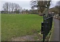
Path next to the Aylestone Recreation Ground (North)
Image: © Mat Fascione
Taken: 21 Jan 2017
0.02 miles
6
Knighton Lane East in Aylestone Park, Leicester
Image: © Mat Fascione
Taken: 22 Nov 2020
0.03 miles
7

Aylestone Recreation Ground North and Knighton Lane East
Image: © Mat Fascione
Taken: 17 Dec 2017
0.04 miles
8
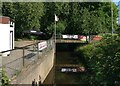
The Saffron Brook in Aylestone
Next to the Friar Lane & Epworth Football Club.
Image: © Mat Fascione
Taken: 17 Jun 2017
0.05 miles
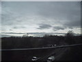
9
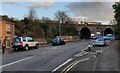
Railway viaduct crossing Knighton Lane East
The viaduct carries the Midland Main Line across the road.
Image: © Mat Fascione
Taken: 4 Nov 2017
0.05 miles
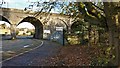
10
Benchmark on railway bridge pier in middle of Knighton Lane East
Ordnance Survey cut mark benchmark described on the Bench Mark Database at www.bench-marks.org.uk/bm88714
Image: © Roger Templeman
Taken: 13 Sep 2017
0.05 miles