IMAGES TAKEN NEAR TO
Knighton Lane East, LEICESTER, LE2 6FR
Introduction
This page details the photographs taken nearby to Knighton Lane East, LE2 6FR by members of the Geograph project.
The Geograph project started in 2005 with the aim of publishing, organising and preserving representative images for every square kilometre of Great Britain, Ireland and the Isle of Man.

There are currently over 7.5m images from over14,400 individuals and you can help contribute to the project by visiting https://www.geograph.org.uk
Image Map
Images are licensed for reuse under creativecommons.org/licenses/by-sa/2.0
Notes
- Clicking on the map will re-center to the selected point.
- The higher the marker number, the further away the image location is from the centre of the postcode.
Image Listing (100 Images Found)
Images are licensed for reuse under creativecommons.org/licenses/by-sa/2.0
Image
Details
Distance
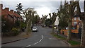
1
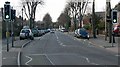
Knighton Lane East, Leicester
Opposite the Sir Jonathan North Community College.
Image: © Mat Fascione
Taken: 1 Mar 2009
0.03 miles
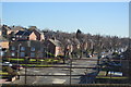
4
The Manchester
The former pub is now student lets.
Image: © Ashley Dace
Taken: 19 Jan 2013
0.06 miles
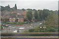
6
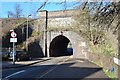
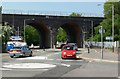
Bridge/Tunnel under the Midland Mainline
This small access bridge/tunnel is well used by traffic but you often see large lorries swearing at Sat Navs. As you can see to the left this is Knightons Field road East, on the other side its Knightons Field road West. The road joins Saffron lane to Welford road. The housing is mostly late 19thC workers terraces accociated with the Co-op factory. The Manchester pub to my left has been converted to yet more student flats but at £105 a week is well over double what I pay!
The junction for the Coalville branch starts here, tube trains from the Old Dalby test site/Derby works can often be heard due to the four class 20's hauling them along.
Image: © Ashley Dace
Taken: 18 Mar 2012
0.07 miles
7
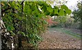
Washbrook Nature Area
Washbrook Nature Area is a small nature reserve sandwiched between the Midland Mainline embankment to the west, Knighton Tennis Centre to the south and Knighton Lane East to the north. Saffron Brook flows through the centre of the park.
Image: © Mat Fascione
Taken: 4 Nov 2017
0.07 miles
8
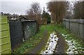
Track next to the Washbrook Nature Area
This track runs behind the houses along Knighton Lane East.
Image: © Mat Fascione
Taken: 17 Dec 2017
0.07 miles
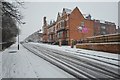
10
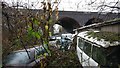
Abandoned vehicles next to the Saffron Brook
Next to the Railway viaduct crossing Knighton Lane East.
Image: © Mat Fascione
Taken: 17 Dec 2017
0.08 miles