IMAGES TAKEN NEAR TO
Longfellow Road, LEICESTER, LE2 6BT
Introduction
This page details the photographs taken nearby to Longfellow Road, LE2 6BT by members of the Geograph project.
The Geograph project started in 2005 with the aim of publishing, organising and preserving representative images for every square kilometre of Great Britain, Ireland and the Isle of Man.

There are currently over 7.5m images from over14,400 individuals and you can help contribute to the project by visiting https://www.geograph.org.uk
Image Map
Images are licensed for reuse under creativecommons.org/licenses/by-sa/2.0
Notes
- Clicking on the map will re-center to the selected point.
- The higher the marker number, the further away the image location is from the centre of the postcode.
Image Listing (50 Images Found)
Images are licensed for reuse under creativecommons.org/licenses/by-sa/2.0
Image
Details
Distance
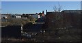
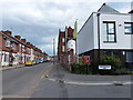
2
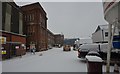
Knighton Fields Road West
The midland mainline can be seen in the distance. I often see trains like the cross countries and Sheffield/Nottingham services. It is nice to see freights cross and I even saw two class 20's on a tube train. You could hear them coming from the distinct engine noise. The Coalville freight line junction is just off to the left. A recreation ground is just off to the right, the houses date from 1892 and housed Shoe workers.
Image: © Ashley Dace
Taken: 15 Oct 2011
0.05 miles
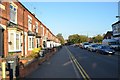
3

Tunnel on Knighton Lane East
The road is passing under the Midland Main Line.
Image: © Mat Fascione
Taken: 15 Jan 2017
0.05 miles
4
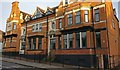
The former Manchester public house
On the corner of Knighton Fields Road East and Burns Street, this former public house has been converted into flats.
Image, taken 9 years earlier.
Image, taken over 12 years earlier.
Image: © Mat Fascione
Taken: 26 May 2020
0.06 miles
5
The Manchester
Public house at the corner of Knighton Fields Road and Burns Street, sadly now boarded up. Compare with Image, which was taked just over three years earlier.
Image, taken nine years later.
Image: © Mat Fascione
Taken: 29 May 2011
0.06 miles
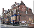
6
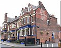
The Manchester
Public house at the corner of Knighton Fields Road and Burns Street. Compare with Image, which was taked just over three years later.
Image: © Mat Fascione
Taken: 18 Mar 2008
0.08 miles
7
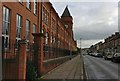
The Wheatsheaf Works in Knighton Fields
The former Co-operative Boot & Shoe Factory, dating back to 1891, on Knighton Fields Road East. In its heyday, Wheatsheaf Works, owned by the Co-operative Wholesale Society, employed 2,500 workers. It closed in 1985.
It is in the process of being converted into 172 townhouses and apartments.
Image: © Mat Fascione
Taken: 20 Nov 2017
0.11 miles
8
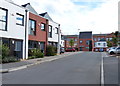
New townhouses on Wheatsheaf Way
Built on the site of the former Wheatsheaf Works.
Image: © Mat Fascione
Taken: 9 Aug 2014
0.11 miles
9
Former Co-op Shoe Factory
Once the largest shoe factory in the world. It's being converted to living accommodation.
Image: © Ashley Dace
Taken: 19 Jan 2013
0.11 miles
10
Junction of Wordsworth Road and Wheatsheaf Way
In the Knighton Fields area of south Leicester.
Image: © Mat Fascione
Taken: 9 Aug 2014
0.12 miles