IMAGES TAKEN NEAR TO
Wigston Road, LEICESTER, LE2 5QF
Introduction
This page details the photographs taken nearby to Wigston Road, LE2 5QF by members of the Geograph project.
The Geograph project started in 2005 with the aim of publishing, organising and preserving representative images for every square kilometre of Great Britain, Ireland and the Isle of Man.

There are currently over 7.5m images from over14,400 individuals and you can help contribute to the project by visiting https://www.geograph.org.uk
Image Map
Images are licensed for reuse under creativecommons.org/licenses/by-sa/2.0
Notes
- Clicking on the map will re-center to the selected point.
- The higher the marker number, the further away the image location is from the centre of the postcode.
Image Listing (48 Images Found)
Images are licensed for reuse under creativecommons.org/licenses/by-sa/2.0
Image
Details
Distance
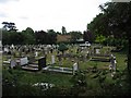
2
Oadby Cemetery
A well maintained site https://www.oadby-wigston.gov.uk/pages/cemeteries
Image: © Tim Heaton
Taken: 4 Oct 2022
0.05 miles
6
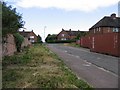
Goddards Slang
What is a slang apart from being part of the name of this street?
Image: © Andrew Tatlow
Taken: 22 Jun 2006
0.12 miles
7
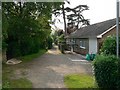
Lawyer's Lane, Oadby
This looks like it should be someone's private driveway, but is in fact a public footpath.
Image: © Mat Fascione
Taken: 3 Jun 2007
0.12 miles
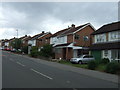
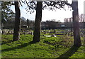
10
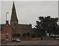
Oadby, Leics LE2
This gives some idea of the position of St Peter's Anglican Church on its small island (triangle) of land. The stationary cars are parked outside the Royal British Legion branch's premises on a short link road connecting Leicester Road (ahead) and Wigston Road on the photographer's right. The white houses behind the cedar trees are on Leicester Road behind the church.
Image: © David Hallam-Jones
Taken: 7 Jan 2013
0.15 miles