IMAGES TAKEN NEAR TO
Shipston Hill, LEICESTER, LE2 5PS
Introduction
This page details the photographs taken nearby to Shipston Hill, LE2 5PS by members of the Geograph project.
The Geograph project started in 2005 with the aim of publishing, organising and preserving representative images for every square kilometre of Great Britain, Ireland and the Isle of Man.

There are currently over 7.5m images from over14,400 individuals and you can help contribute to the project by visiting https://www.geograph.org.uk
Image Map
Images are licensed for reuse under creativecommons.org/licenses/by-sa/2.0
Notes
- Clicking on the map will re-center to the selected point.
- The higher the marker number, the further away the image location is from the centre of the postcode.
Image Listing (25 Images Found)
Images are licensed for reuse under creativecommons.org/licenses/by-sa/2.0
Image
Details
Distance
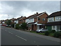
1
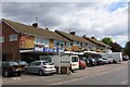
Shops on Rosemead Drive
There are shops behind the cars, honest!
Image: © Andrew Tatlow
Taken: 22 Jun 2006
0.09 miles
3
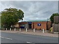
Oadby United Reformed Church
https://southleicsgroupurc.org.uk/october-2022-group-magazine/
Image: © Tim Heaton
Taken: 4 Oct 2022
0.14 miles

7
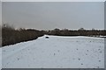
Brocks Hill Country Park
A snowed over country park at the southern end of Leicester.
Image: © Ashley Dace
Taken: 1 Dec 2010
0.18 miles
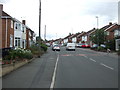
8
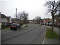
Briar Walk, Oadby
Seen from the junction with Ash Tree Road.
Image: © Richard Vince
Taken: 11 Mar 2017
0.19 miles
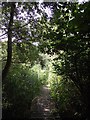
9
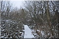
Lucas Marsh Nature Reserve
A board walk in this small nature reserve. Image]
Image: © Ashley Dace
Taken: 1 Dec 2010
0.19 miles
10

Lucas Marsh Nature Reserve
A board walk in the nature reserveImage]
Image: © Ashley Dace
Taken: 1 Dec 2010
0.20 miles