IMAGES TAKEN NEAR TO
Kenilworth Drive, LEICESTER, LE2 5LT
Introduction
This page details the photographs taken nearby to Kenilworth Drive, LE2 5LT by members of the Geograph project.
The Geograph project started in 2005 with the aim of publishing, organising and preserving representative images for every square kilometre of Great Britain, Ireland and the Isle of Man.

There are currently over 7.5m images from over14,400 individuals and you can help contribute to the project by visiting https://www.geograph.org.uk
Image Map
Images are licensed for reuse under creativecommons.org/licenses/by-sa/2.0
Notes
- Clicking on the map will re-center to the selected point.
- The higher the marker number, the further away the image location is from the centre of the postcode.
Image Listing (13 Images Found)
Images are licensed for reuse under creativecommons.org/licenses/by-sa/2.0
Image
Details
Distance
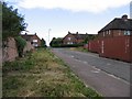
1

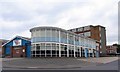
Industrial Estate buildings
Each occupant sets their own style! About half of this square is occupied by the Leicester Racecourse but it is difficult to see it as it is almost entirely surrounded by houses and industrial estate buildings.
Image: © Andrew Tatlow
Taken: 19 Jun 2006
0.07 miles
2
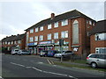
Industrial premises
A large portion of this square is occupied by an industrial estate that has evolved over the past 50 years. It contains an amazing range of different buildings.
Image: © Andrew Tatlow
Taken: 19 Jun 2006
0.12 miles
3
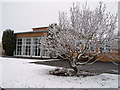
January Snow at Langmoor Primary School
You can see the magnolia tree in front of the school's hall, one wintry morning.
Image: © Emma Payne
Taken: Unknown
0.13 miles
4
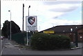
Oval Park, Wigston Road, Oadby
This is the training ground for Leicester Rugby Football Club. It is also the home of Oadby Wiggs.
Image: © Steve Rowe
Taken: 24 Jul 2007
0.15 miles
5
Oval Park, Wigston Road, Oadby
This is the training ground for Leicester Rugby Football Club. It is also the home of Oadby Wiggs.
Image: © Steve Rowe
Taken: 24 Jul 2007
0.16 miles
6
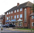
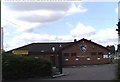
1953 Shops Brabazon Road
Shops built as part of a council estate in 1953.
Image: © Andrew Tatlow
Taken: 22 Jun 2006
0.17 miles
10
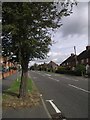
Goddards Slang
What is a slang apart from being part of the name of this street?
Image: © Andrew Tatlow
Taken: 22 Jun 2006
0.23 miles