IMAGES TAKEN NEAR TO
Weston Rise, LEICESTER, LE2 4WA
Introduction
This page details the photographs taken nearby to Weston Rise, LE2 4WA by members of the Geograph project.
The Geograph project started in 2005 with the aim of publishing, organising and preserving representative images for every square kilometre of Great Britain, Ireland and the Isle of Man.

There are currently over 7.5m images from over14,400 individuals and you can help contribute to the project by visiting https://www.geograph.org.uk
Image Map
Images are licensed for reuse under creativecommons.org/licenses/by-sa/2.0
Notes
- Clicking on the map will re-center to the selected point.
- The higher the marker number, the further away the image location is from the centre of the postcode.
Image Listing (19 Images Found)
Images are licensed for reuse under creativecommons.org/licenses/by-sa/2.0
Image
Details
Distance
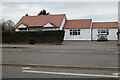
1
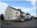
New houses by Glen Road, Oadby
This is the Cottage Farm Estate by Bloor Homes. https://bloorhomes.com/developments/leicestershire/oadby/cottage-farm
Image: © David Howard
Taken: 5 Mar 2023
0.13 miles

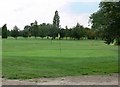
4
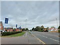
Glen Gorse Golf Club, Oadby
A public footpath leads down Mere Lane, past the golf course, and across the fields to Newton Lane.
Image: © Mat Fascione
Taken: 19 Jul 2007
0.15 miles

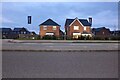
8
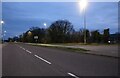
Glen Road entering Oadby
Bloor Homes' Cottage Farm development on the left. A further extension of the Leicester urban area to the south-east.
Image: © Tim Heaton
Taken: 4 Oct 2022
0.17 miles