IMAGES TAKEN NEAR TO
Quorn Avenue, LEICESTER, LE2 4SH
Introduction
This page details the photographs taken nearby to Quorn Avenue, LE2 4SH by members of the Geograph project.
The Geograph project started in 2005 with the aim of publishing, organising and preserving representative images for every square kilometre of Great Britain, Ireland and the Isle of Man.

There are currently over 7.5m images from over14,400 individuals and you can help contribute to the project by visiting https://www.geograph.org.uk
Image Map
Images are licensed for reuse under creativecommons.org/licenses/by-sa/2.0
Notes
- Clicking on the map will re-center to the selected point.
- The higher the marker number, the further away the image location is from the centre of the postcode.
Image Listing (21 Images Found)
Images are licensed for reuse under creativecommons.org/licenses/by-sa/2.0
Image
Details
Distance
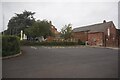
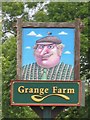
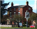
3
Grange Farm, Oadby Grange
Apparently considerably older than the fairly recent housing surrounding it; now a pub restaurant.
Image: © Richard Vince
Taken: 11 Mar 2017
0.10 miles

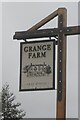
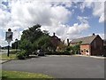
5
Grange Farm public house
On Florence Wragg Way in Oadby.
Image: © Mat Fascione
Taken: 1 Mar 2014
0.10 miles