IMAGES TAKEN NEAR TO
Kent Drive, LEICESTER, LE2 4PN
Introduction
This page details the photographs taken nearby to Kent Drive, LE2 4PN by members of the Geograph project.
The Geograph project started in 2005 with the aim of publishing, organising and preserving representative images for every square kilometre of Great Britain, Ireland and the Isle of Man.

There are currently over 7.5m images from over14,400 individuals and you can help contribute to the project by visiting https://www.geograph.org.uk
Image Map
Images are licensed for reuse under creativecommons.org/licenses/by-sa/2.0
Notes
- Clicking on the map will re-center to the selected point.
- The higher the marker number, the further away the image location is from the centre of the postcode.
Image Listing (18 Images Found)
Images are licensed for reuse under creativecommons.org/licenses/by-sa/2.0
Image
Details
Distance
2
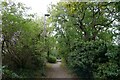
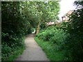
Footpath through Oadby to Glen Road (A6)
The footpath starts off the Roman road at Great Stretton, and follows Wash Brook
Image: © Tim Heaton
Taken: 4 Oct 2022
0.09 miles
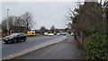
6
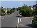
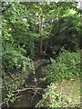
Severn Road
The road crosses a small brook.
Image: © Andrew Tatlow
Taken: 19 Jun 2006
0.17 miles
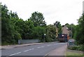
8
The A6 at Oadby
The A6 is a major arterial route into Leicester.
Image: © Peter Mackenzie
Taken: 28 Dec 2019
0.18 miles
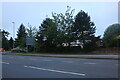
9
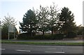
Glen Road, Oadby
The A6 changes its name about four times over a few miles from here to the Leicester suburbs. The Croft Medical Centre is hiding behind the trees.
Image: © David Howard
Taken: 20 Sep 2020
0.19 miles
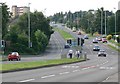
10
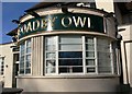
The Oadby Owl
Public house along the A6 Glen Road in Oadby.
Image: © Mat Fascione
Taken: 13 Mar 2011
0.19 miles