IMAGES TAKEN NEAR TO
Tudor Drive, LEICESTER, LE2 4NP
Introduction
This page details the photographs taken nearby to Tudor Drive, LE2 4NP by members of the Geograph project.
The Geograph project started in 2005 with the aim of publishing, organising and preserving representative images for every square kilometre of Great Britain, Ireland and the Isle of Man.

There are currently over 7.5m images from over14,400 individuals and you can help contribute to the project by visiting https://www.geograph.org.uk
Image Map
Images are licensed for reuse under creativecommons.org/licenses/by-sa/2.0
Notes
- Clicking on the map will re-center to the selected point.
- The higher the marker number, the further away the image location is from the centre of the postcode.
Image Listing (40 Images Found)
Images are licensed for reuse under creativecommons.org/licenses/by-sa/2.0
Image
Details
Distance
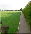
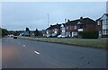
1
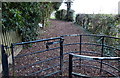
Footpath on Uplands Park in Oadby
This is the Tudor Drive entrance to Uplands Park.
Image: © Mat Fascione
Taken: 9 Dec 2012
0.04 miles
2
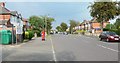
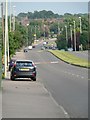
Uplands Road, Oadby
The entrance to Uplands Road Park is on the left of the photo.
Image: © Mat Fascione
Taken: 3 Jun 2007
0.08 miles


10
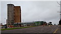
Oadby, Leics LE2
Stoughton House and a new supermarket (2011/12) gracing the edge of Oadby shopping area, at the side of the A6 road. This is the view towards Leicester city centre.
Image: © David Hallam-Jones
Taken: 7 Jan 2013
0.17 miles