IMAGES TAKEN NEAR TO
Martin Avenue, LEICESTER, LE2 4NH
Introduction
This page details the photographs taken nearby to Martin Avenue, LE2 4NH by members of the Geograph project.
The Geograph project started in 2005 with the aim of publishing, organising and preserving representative images for every square kilometre of Great Britain, Ireland and the Isle of Man.

There are currently over 7.5m images from over14,400 individuals and you can help contribute to the project by visiting https://www.geograph.org.uk
Image Map
Images are licensed for reuse under creativecommons.org/licenses/by-sa/2.0
Notes
- Clicking on the map will re-center to the selected point.
- The higher the marker number, the further away the image location is from the centre of the postcode.
Image Listing (14 Images Found)
Images are licensed for reuse under creativecommons.org/licenses/by-sa/2.0
Image
Details
Distance
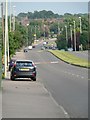
1
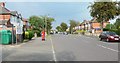
Uplands Road, Oadby
The entrance to Uplands Road Park is on the left of the photo.
Image: © Mat Fascione
Taken: 3 Jun 2007
0.07 miles
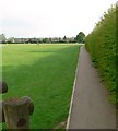
2
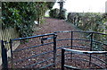
Footpath on Uplands Park in Oadby
This is the Tudor Drive entrance to Uplands Park.
Image: © Mat Fascione
Taken: 9 Dec 2012
0.14 miles
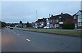

8
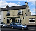
The Wheel Inn
Public House on London Road in Oadby.
Image: © Mat Fascione
Taken: 19 Jul 2007
0.21 miles
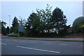
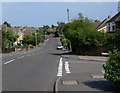
10
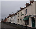
Oadby, Leics LE2
A row of terraced houses on London Road (the B5403) dated "1870" and labelled "Manchester Cottages". This is a view towards Oadby town centre from the junction with King Street.
Image: © David Hallam-Jones
Taken: 7 Jan 2013
0.22 miles