IMAGES TAKEN NEAR TO
Hursley Close, LEICESTER, LE2 4JG
Introduction
This page details the photographs taken nearby to Hursley Close, LE2 4JG by members of the Geograph project.
The Geograph project started in 2005 with the aim of publishing, organising and preserving representative images for every square kilometre of Great Britain, Ireland and the Isle of Man.

There are currently over 7.5m images from over14,400 individuals and you can help contribute to the project by visiting https://www.geograph.org.uk
Image Map
Images are licensed for reuse under creativecommons.org/licenses/by-sa/2.0
Notes
- Clicking on the map will re-center to the selected point.
- The higher the marker number, the further away the image location is from the centre of the postcode.
Image Listing (22 Images Found)
Images are licensed for reuse under creativecommons.org/licenses/by-sa/2.0
Image
Details
Distance
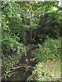
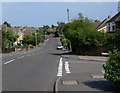
2
Severn Road
The road crosses a small brook.
Image: © Andrew Tatlow
Taken: 19 Jun 2006
0.04 miles
3
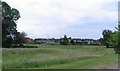
Open space and houses off Severn Road
Image: © Andrew Tatlow
Taken: 19 Jun 2006
0.07 miles
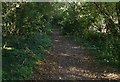
4
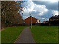
Path to Malham Way in Oadby
This path runs between Severn Road and Malham Way, the trees on the left are along Fludes Lane.
Image: © Mat Fascione
Taken: 1 Mar 2014
0.10 miles
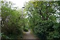
5
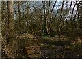
Fludes Lane in Oadby
A path through a small nature area that follows the course of Wash Brook.
Image: © Mat Fascione
Taken: 17 Oct 2010
0.11 miles
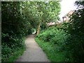
6
Footpath through Oadby to Glen Road (A6)
The footpath starts off the Roman road at Great Stretton, and follows Wash Brook
Image: © Tim Heaton
Taken: 4 Oct 2022
0.12 miles
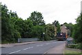
10
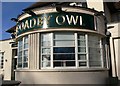
The Oadby Owl
Public house along the A6 Glen Road in Oadby.
Image: © Mat Fascione
Taken: 13 Mar 2011
0.16 miles