IMAGES TAKEN NEAR TO
Manor Road Extension, LEICESTER, LE2 4FG
Introduction
This page details the photographs taken nearby to Manor Road Extension, LE2 4FG by members of the Geograph project.
The Geograph project started in 2005 with the aim of publishing, organising and preserving representative images for every square kilometre of Great Britain, Ireland and the Isle of Man.

There are currently over 7.5m images from over14,400 individuals and you can help contribute to the project by visiting https://www.geograph.org.uk
Image Map
Images are licensed for reuse under creativecommons.org/licenses/by-sa/2.0
Notes
- Clicking on the map will re-center to the selected point.
- The higher the marker number, the further away the image location is from the centre of the postcode.
Image Listing (17 Images Found)
Images are licensed for reuse under creativecommons.org/licenses/by-sa/2.0
Image
Details
Distance
3
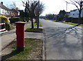
Postbox along Manor Road Extension in Oadby
Image: © Mat Fascione
Taken: 1 Mar 2014
0.08 miles
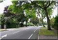
6
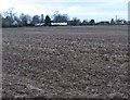
Farmland near Oadby
The houses are along Stoughton Road.
Image: © Mat Fascione
Taken: 9 Dec 2012
0.11 miles
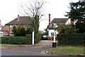
7
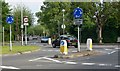
Give way again!
This is one of the two mini roundabouts at the junction of Stoughton Road, Manor Road, and Manor Road Extension. Photographed looking southeast along Manor Road Extension.
Image: © Mat Fascione
Taken: 3 Jun 2007
0.12 miles
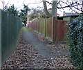
8
Junction of Manor Road and Stoughton Road
Image: © Andrew Tatlow
Taken: 8 Sep 2011
0.12 miles