IMAGES TAKEN NEAR TO
Glebe Close, LEICESTER, LE2 2LA
Introduction
This page details the photographs taken nearby to Glebe Close, LE2 2LA by members of the Geograph project.
The Geograph project started in 2005 with the aim of publishing, organising and preserving representative images for every square kilometre of Great Britain, Ireland and the Isle of Man.

There are currently over 7.5m images from over14,400 individuals and you can help contribute to the project by visiting https://www.geograph.org.uk
Image Map
Images are licensed for reuse under creativecommons.org/licenses/by-sa/2.0
Notes
- Clicking on the map will re-center to the selected point.
- The higher the marker number, the further away the image location is from the centre of the postcode.
Image Listing (49 Images Found)
Images are licensed for reuse under creativecommons.org/licenses/by-sa/2.0
Image
Details
Distance

2

Road sign for Grenfell Road, South Knighton
Image: © David Howard
Taken: 20 Sep 2020
0.05 miles
3
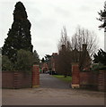
Botanical Gardens, LE2
The entrance/exit to The Knoll, off Glebe Road. The original Leicester, Leics & Rutland College botanical garden complex (later to become The University of Leicester botanical garden) existed near Victoria Park between 1921-25 and it remained there until 1947 when the demand for space there made a move elsewhere necessary. Four houses (that were all designed by Stockdale Harrison), each with their respective gardens, were gradually purchased - Hastings in 1902, Beaumont in 1904, The Knoll in 1908 and Southmeade in 1928 - in order to provide additional Halls and to facilitate the development of a new Botanical Garden complex.
Image: © David Hallam-Jones
Taken: 7 Jan 2013
0.07 miles

5

Benchmark on #453 London Road (former tram depot PC)
Ordnance Survey cut mark bench mark described on the Bench Mark Database at https://www.bench-marks.org.uk/bm102226
Image: © Roger Templeman
Taken: 8 May 2018
0.08 miles
6
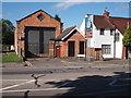
London Road, Oadby, Leics.
No. 453 London Road, in the vicinity of the Botanical Gardens, is the former Stoneygate Tram Depot. It has been described as a rare example of an outlying tram depot. It was built to stable and service trams on the newly extended electrified municipal tram route between the city centre and Stoneygate vicinity of Oadby, operational between 1904-1922. See: http://www.ltht.org.uk/wp-content/uploads/2016/01/Stoneygate-Tram-Depot-Key-Facts-Sheet.pdf
Image: © David Hallam-Jones
Taken: 24 Jun 2016
0.08 miles
9
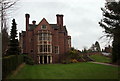
Botanical Gardens, LE2
End elevation, Knoll House. The original Leicester, Leics & Rutland College botanical garden complex (later to become The University of Leicester botanical garden) existed near Victoria Park between 1921-25 and it remained there until 1947 when the demand for space there made a move elsewhere necessary. Four houses (that were all designed by Stockdale Harrison), each with their respective gardens, were gradually purchased - Hastings in 1902, Beaumont in 1904, The Knoll in 1908 and Southmeade in 1928 - in order to provide additional Halls and to facilitate the development of a new Botanical Garden complex. Vehicular access to this block is via Glebe Road.
Image: © David Hallam-Jones
Taken: 7 Jan 2013
0.08 miles
10
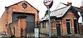
Transport Trust Stoneygate Tram Depot and public convenience
Image: © Roger Templeman
Taken: 26 May 2022
0.08 miles