IMAGES TAKEN NEAR TO
Gartree Road, LEICESTER, LE2 2FB
Introduction
This page details the photographs taken nearby to Gartree Road, LE2 2FB by members of the Geograph project.
The Geograph project started in 2005 with the aim of publishing, organising and preserving representative images for every square kilometre of Great Britain, Ireland and the Isle of Man.

There are currently over 7.5m images from over14,400 individuals and you can help contribute to the project by visiting https://www.geograph.org.uk
Image Map
Images are licensed for reuse under creativecommons.org/licenses/by-sa/2.0
Notes
- Clicking on the map will re-center to the selected point.
- The higher the marker number, the further away the image location is from the centre of the postcode.
Image Listing (20 Images Found)
Images are licensed for reuse under creativecommons.org/licenses/by-sa/2.0
Image
Details
Distance
1
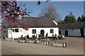
The Cow and Plough, Oadby
Spring seems to have arrived at this popular venue on the outskirts of Leicester with blossom in the foreground and plenty of people taking advantage of the balmy mid-March weather to drink outside. The sign describes these converted farm buildings as a bar and eating house - pub and restaurant to the rest of us.
Image: © Stephen McKay
Taken: 11 Mar 2012
0.02 miles
2
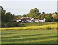
Stoughton Grange Centre, Oadby, Leics.
Part of the Stoughton Grange Rural Centre, Oadby. This centre is located on the side of the B582 (a.k.a. Gartree Road). It was previously a working farm known as Grange Farm but has for many years offered non-industrial commercial units to various businesses and retail outlets, including a well-known gastro-pub called "The Cow and Plough". This pub serves beers brewed by “The Steamin' Billy” group. In 1994 an alliance was formed when 19 year old William (“Bill”) Allingham of Leatherbritches Brewery brewed a house beer for Licensee Barry Lount of The Cow & Plough. They called the beer Steamin’ Billy after Barry’s family Jack Russell terrier. In 1996 Allingham & Lount formed Steamin Billy Brewing Co. Ltd in order to develop a chain of new pubs. Steamin' Billy beers are now brewed under licence at Belvoir Brewery in Old Dalby, Leicester.
Image: © David Hallam-Jones
Taken: 10 May 2018
0.03 miles
3
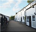
Stoughton Grange Centre, Oadby, Leics.
A couple of the smaller properties that form part of the Stoughton Grange Rural Centre, Oadby. This centre is located on the side of the B582 (a.k.a. Gartree Road). It was previously a working farm known as Grange Farm but has for many years offered non-industrial commercial units to various businesses and retail outlets, including a well-known gastro-pub called "The Cow and Plough" that is situated further inside the complex.
Image: © David Hallam-Jones
Taken: 10 May 2018
0.06 miles
4
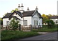
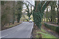
Junction of Stoughton Road and Gartree Road
Image: © Mat Fascione
Taken: 3 Jun 2007
0.08 miles
5
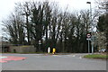
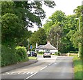
Roundabout at the end of Stoughton Road, Oadby
Gartree Road is on the right. This is the edge of the Leicester urban area.
Image: © David Howard
Taken: 5 Mar 2023
0.11 miles
6
Stoughton Grange Centre, Oadby, Leics.
A view of Stoughton Grange Rural Centre, Oadby from a rural footpath that runs from Manor Road towards Shady Lane. This centre is located on the side of the B582 (a.k.a. Gartree Road). It was previously a working farm known as Grange Farm but has for many years offered non-industrial commercial units to various businesses and retail outlets, including a well-known gastro-pub called "The Cow and Plough".
Image: © David Hallam-Jones
Taken: 10 May 2018
0.13 miles
7
Shady Lane, Evington
The junction with Gartree Road
Image: © Kate Jewell
Taken: 17 Jan 2006
0.15 miles
8
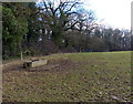
Cattle trough and field near Stackyard Spinney
Gartree Road is on the left behind the trees.
Image: © Mat Fascione
Taken: 11 Jan 2014
0.17 miles

