IMAGES TAKEN NEAR TO
Gartree Road, LEICESTER, LE2 2FA
Introduction
This page details the photographs taken nearby to Gartree Road, LE2 2FA by members of the Geograph project.
The Geograph project started in 2005 with the aim of publishing, organising and preserving representative images for every square kilometre of Great Britain, Ireland and the Isle of Man.

There are currently over 7.5m images from over14,400 individuals and you can help contribute to the project by visiting https://www.geograph.org.uk
Image Map
Images are licensed for reuse under creativecommons.org/licenses/by-sa/2.0
Notes
- Clicking on the map will re-center to the selected point.
- The higher the marker number, the further away the image location is from the centre of the postcode.
Image Listing (5 Images Found)
Images are licensed for reuse under creativecommons.org/licenses/by-sa/2.0
Image
Details
Distance
1
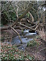
Evington Brook
Tangle of dying tree branches across Evington Brook, in Evington Arboretum.
Image: © Colin Hoskins
Taken: 22 Feb 2009
0.14 miles
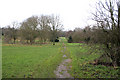
2
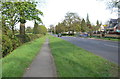
Path along Gartree Road in Oadby
To the left of the hedge is the Leicestershire Golf Club.
Image: © Mat Fascione
Taken: 13 May 2012
0.14 miles
3
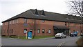
BUPA Private Hospital
A large private hospital run by the British United Provident Association.
Image: © Andrew Tatlow
Taken: 15 Apr 2006
0.14 miles
4
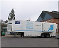
Computed Tomography
The BUPA hospital makes use of a mobile CT Scanner.
Image: © Andrew Tatlow
Taken: 15 Apr 2006
0.16 miles
5
Arboretum, Evington
On Shady Lane this popular open area is situated in the south east corner of the golf course.
Image: © Kate Jewell
Taken: 17 Jan 2006
0.22 miles