IMAGES TAKEN NEAR TO
Cromer Street, LEICESTER, LE2 1PG
Introduction
This page details the photographs taken nearby to Cromer Street, LE2 1PG by members of the Geograph project.
The Geograph project started in 2005 with the aim of publishing, organising and preserving representative images for every square kilometre of Great Britain, Ireland and the Isle of Man.

There are currently over 7.5m images from over14,400 individuals and you can help contribute to the project by visiting https://www.geograph.org.uk
Image Map
Images are licensed for reuse under creativecommons.org/licenses/by-sa/2.0
Notes
- Clicking on the map will re-center to the selected point.
- The higher the marker number, the further away the image location is from the centre of the postcode.
Image Listing (29 Images Found)
Images are licensed for reuse under creativecommons.org/licenses/by-sa/2.0
Image
Details
Distance
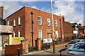
1
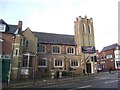
The MKA Dashwood Venue
Formerly a United Reformed Church founded in 1925.
Image: © Tim Glover
Taken: 3 Apr 2016
0.07 miles
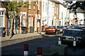
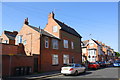
2
Devana Road, Leicester
Taking its name from the Via Devana, the Roman road which used to enter Leicester from the south-east along a route close to here. The most likely line of the route, however, was along the neighbouring Kimberley Road, as it coincides with the former parish boundary and runs into the Evington Footway.
Image: © Tim Heaton
Taken: 29 Dec 2023
0.08 miles
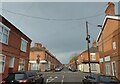
3
Earl Howe Street Leicester
Looking towards Mere Road.
Image: © Terry Roberts
Taken: Unknown
0.09 miles
4
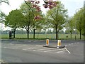
Victoria Park, Stoneygate, Leicester
Taken near the junction of A6 (London Road) and B568 (Victoria Park Road)
Image: © Richard Howell
Taken: 23 Apr 2003
0.09 miles
5
#13 Beckingham Road at Tennyson Street junction
Image: © Roger Templeman
Taken: 5 May 2017
0.13 miles
6
Rear gates of houses on East Park Road
The rear gates are on Mere Road: East Park Road runs along the fronts of the houses!
Image: © Andrew Tatlow
Taken: 25 Apr 2012
0.13 miles
7
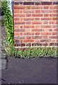
Benchmark on BT telephone exchange, Evington Road
Ordnance Survey cut mark benchmark described on the Bench Mark Database at www.bench-marks.org.uk/bm88693
Image: © phil Richards
Taken: 9 Sep 2017
0.13 miles
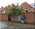
8
Telephone Exchange, NW side Evington Road
There is an Ordnance Survey benchmark Image on the front of the building about 18" from its near corner
Image: © phil Richards
Taken: 9 Sep 2017
0.14 miles
10
Mere Road towards Spinney Hills
There are no houses on this section of Mere Road which runs along the backs of the houses on East Park Road and Evington Place.
Image: © Andrew Tatlow
Taken: 25 Apr 2012
0.17 miles