IMAGES TAKEN NEAR TO
Connaught Street, LEICESTER, LE2 1FJ
Introduction
This page details the photographs taken nearby to Connaught Street, LE2 1FJ by members of the Geograph project.
The Geograph project started in 2005 with the aim of publishing, organising and preserving representative images for every square kilometre of Great Britain, Ireland and the Isle of Man.

There are currently over 7.5m images from over14,400 individuals and you can help contribute to the project by visiting https://www.geograph.org.uk
Image Map
Images are licensed for reuse under creativecommons.org/licenses/by-sa/2.0
Notes
- Clicking on the map will re-center to the selected point.
- The higher the marker number, the further away the image location is from the centre of the postcode.
Image Listing (143 Images Found)
Images are licensed for reuse under creativecommons.org/licenses/by-sa/2.0
Image
Details
Distance
1
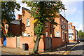
No. 63 Hamilton Street at Evington Road junction
Ordnance Survey documents indicate that in 1965 a benchmark levelled at 87.2225 was verified on the corner, left hand face, of the boundary wall, sections of which have been rebuilt.
Image: © phil Richards
Taken: 9 Sep 2017
0.05 miles
2
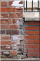
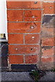
Benchmark on #48 Upper Tichborne Street (Avon Street face)
Ordnance Survey cut mark benchmark described on the Bench Mark Database at www.bench-marks.org.uk/bm88678
Image: © phil Richards
Taken: 9 Sep 2017
0.05 miles
3
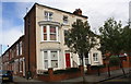
#48 Upper Tichborne Street at Avon Street junction
There is an Ordnance Survey benchmark Image on the left hand side of the nearest house at its junction with its front side wall
Image: © phil Richards
Taken: 9 Sep 2017
0.07 miles
4
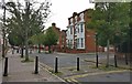
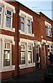
Skipworth and Medway Streets in Highfields, Leicester
Image: © Mat Fascione
Taken: 4 Sep 2020
0.07 miles
5
Benchmark on #57 Skipworth Street
Ordnance Survey cut mark benchmark described on the Bench Mark Database at http://www.bench-marks.org.uk/bm84485
Image: © Roger Templeman
Taken: 5 May 2017
0.07 miles
6
Houses on Skipworth Street
There is an OS benchmark Image in the bricks to the right of the woman in a doorway
Image: © Roger Templeman
Taken: 5 May 2017
0.07 miles
7
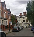
St Albans Road in Highfields, Leicester
Image: © Mat Fascione
Taken: 23 Sep 2019
0.08 miles
8
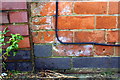
Benchmark on #46 Severn Street (Welland Street face)
Ordnance Survey cut mark benchmark described on the Bench Mark Database at www.bench-marks.org.uk/bm88692
Image: © phil Richards
Taken: 9 Sep 2017
0.09 miles
9
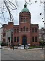
Leicester Synagogue
Leicester Synagogue was built in 1898 and designed by Arthur Wakerley. The building is Grade II listed, see: https://historicengland.org.uk/listing/the-list/list-entry/1389696
Image: © Philip Halling
Taken: 20 Nov 2021
0.09 miles
10
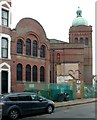
Leicester Hebrew Congregation synagogue, Highfield Street
The building works include the conversion of the schoolroom, to the left into a Visitor Centre with improved ancillary features. Built 1897-8, architect Arthur Wakerley, in Byzantine style. Listed Grade II.
Image: © Alan Murray-Rust
Taken: 26 Jan 2019
0.10 miles