IMAGES TAKEN NEAR TO
London Road, LEICESTER, LE2 0QS
Introduction
This page details the photographs taken nearby to London Road, LE2 0QS by members of the Geograph project.
The Geograph project started in 2005 with the aim of publishing, organising and preserving representative images for every square kilometre of Great Britain, Ireland and the Isle of Man.

There are currently over 7.5m images from over14,400 individuals and you can help contribute to the project by visiting https://www.geograph.org.uk
Image Map
Images are licensed for reuse under creativecommons.org/licenses/by-sa/2.0
Notes
- Clicking on the map will re-center to the selected point.
- The higher the marker number, the further away the image location is from the centre of the postcode.
Image Listing (286 Images Found)
Images are licensed for reuse under creativecommons.org/licenses/by-sa/2.0
Image
Details
Distance
1
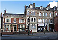
Leicester - London Road shops
Opposite The Landsdowne pub.
Image: © Dave Bevis
Taken: 16 Feb 2014
0.02 miles
2
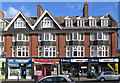
Leicester - London Road shops
Opposite University Road junction.
Image: © Dave Bevis
Taken: 16 Feb 2014
0.02 miles
3
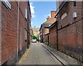
Victoria Avenue in Leicester
A small cobbled cul-de-sac located off the busy London Road in Leicester city centre. It is part of the South Highfields Conservation Area.
Image: © Mat Fascione
Taken: 29 Jul 2024
0.02 miles
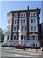
4

Leicester, LE2 - London Road
The front elevation of the Leicester Central Seventh Day Adventist Church seen from Victoria Avenue. Victoria Avenue is a short, unadopted cul-de-sac within the Highfields Conservation Area.
Image: © David Hallam-Jones
Taken: 9 Dec 2012
0.03 miles
6
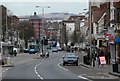
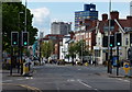
London Road in Leicester
The high ground in the distance is Bradgate Park, about six miles as the crow flies.
Image: © Mat Fascione
Taken: 18 Mar 2008
0.04 miles
7
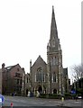
Seventh Day Adventist Church, London Road, Leicester
Originally the Victoria Road Baptist Church. Late 19th century in generally Decorated Gothic style with an impressive spire. Listed Grade II.
Image: © Alan Murray-Rust
Taken: 26 Jan 2019
0.04 miles
8
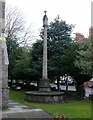
War Memorial, Victoria Road Baptist Church
Lantern cross and column of Clipsham stone on octagonal plinth, in the grounds of the former Victoria Road Baptist Church; dedicated in 1920. Listed Grade II. (The church is now occupied by the Seventh Day Adventist Church.)
Image: © Alan Murray-Rust
Taken: 26 Jan 2019
0.04 miles
9
#5 Saxby Street at junction of Gotham Street
The building is occupied by Athena Care. Ordnance Survey documents indicate that in 1965 a benchmark levelled at 79.830m above Newlyn Datum was verified on the left hand side of the building at its front corner
Image: © phil Richards
Taken: 9 Sep 2017
0.04 miles
10
London Road towards Leicester City centre
At the junction with Universiy Road.
Image: © Mat Fascione
Taken: 1 May 2017
0.04 miles