1
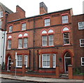
Nos. 46 and 48 Highfield Street (Elliot Residential Care Home)
There is an Ordnance Survey benchmark
Image on the left hand side of the entrance door to the right hand house.
Image: © phil Richards
Taken: 9 Sep 2017
0.03 miles
2
Leicester - terrace towards north end of Highfield Street
Image: © Dave Bevis
Taken: 16 Feb 2014
0.05 miles
3
Benchmark and Virgin Media box on #48 Highfield Street
Ordnance Survey cut mark benchmark described on the Bench Mark Database at www.bench-marks.org.uk/bm88691
Image: © phil Richards
Taken: 9 Sep 2017
0.05 miles
4
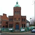
Leicester Hebrew Congregation synagogue, Highfield Street
Detail of the tower. See also http://www.geograph.org.uk/photo/6036692.
Image: © Alan Murray-Rust
Taken: 26 Jan 2019
0.05 miles
5
Leicester, LE1 - Highfield Street
A glance along Highfield Street towards Sparkenhoe Street reveals a former Jewish School (c. 1902) associated with the former Orthodox Synagogue to the right of the Holly tree. The school premises, the synagogue and an associated community centre (obliquely opposite) are currently "For Sale" due to a drastic reduction in the size of its congregation. London Road (i.e. A6) lies behind the photographer.
Image: © David Hallam-Jones
Taken: 9 Dec 2012
0.05 miles
6
Leicester Hebrew Congregation synagogue, Highfield Street
The building works include the conversion of the schoolroom, to the left into a Visitor Centre with improved ancillary features. Built 1897-8, architect Arthur Wakerley, in Byzantine style. Listed Grade II.
Image: © Alan Murray-Rust
Taken: 26 Jan 2019
0.06 miles
7
Leicester - three houses on Highfield Street
North of junction with Gotham Street.
Image: © Dave Bevis
Taken: 16 Feb 2014
0.06 miles
8
Leicester, LE1 - Highfield Street
"The Leicester Mercury" newspaper reported this synagogue as being "For Sale" in October 2011 and the advertising hoarding has now disappeared. This building was completed in 1898 and in 1950, as a result of the war-time expansion of its congregation, a community centre was built opposite it in Tichborne Street. This was the sole orthodox Jewish synagogue in Leicestershire. It seems that the community members are hoping that the sale of the synagogue and the community centre will provide sufficient funds for the purchase of alternative premises in Oadby. London Road (i.e. the A6) is situated behind the photographer.
Image: © David Hallam-Jones
Taken: 9 Dec 2012
0.06 miles
9
Leicester Hebrew Congregation synagogue, Highfield Street
The building works include the conversion of the schoolroom, to the left into a Visitor Centre with improved ancillary features. Built 1897-8, architect Arthur Wakerley in Byzantine style. Listed Grade II. The main front with copper-covered dome topping the tower.
Image: © Alan Murray-Rust
Taken: 26 Jan 2019
0.06 miles
10
Gotham Street, Highfields
Seen from Saxby Street.
Image: © Richard Vince
Taken: 11 Mar 2017
0.06 miles


