IMAGES TAKEN NEAR TO
Brookhouse Avenue, LEICESTER, LE2 0JE
Introduction
This page details the photographs taken nearby to Brookhouse Avenue, LE2 0JE by members of the Geograph project.
The Geograph project started in 2005 with the aim of publishing, organising and preserving representative images for every square kilometre of Great Britain, Ireland and the Isle of Man.

There are currently over 7.5m images from over14,400 individuals and you can help contribute to the project by visiting https://www.geograph.org.uk
Image Map
Images are licensed for reuse under creativecommons.org/licenses/by-sa/2.0
Notes
- Clicking on the map will re-center to the selected point.
- The higher the marker number, the further away the image location is from the centre of the postcode.
Image Listing (420 Images Found)
Images are licensed for reuse under creativecommons.org/licenses/by-sa/2.0
Image
Details
Distance
3
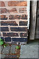
Benchmark on #4A Prebend Street
Ordnance Survey cut mark benchmark described on the Bench Mark Database at http://www.bench-marks.org.uk/bm84152
Image: © Roger Templeman
Taken: 4 May 2017
0.04 miles
4
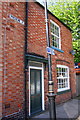
#4A Prebend Street
There is an OS benchmark Image in the bricks left of the wooden gate under the To Let sign
Image: © Roger Templeman
Taken: 4 May 2017
0.04 miles
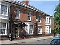
5
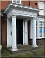
Portico, 80 London Road, Leicester
See http://www.geograph.org.uk/photo/6039229 for location.
Image: © Alan Murray-Rust
Taken: 26 Jan 2019
0.06 miles
6
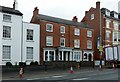
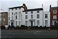
80 London Road, Leicester
What would seem to have been originally two houses (since converted to offices) now share a common address. Early 19 century, with early 20th century recessed porch on the right. Listed Grade II.
Image: © Alan Murray-Rust
Taken: 26 Jan 2019
0.06 miles
7
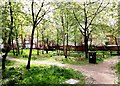
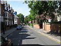
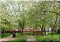
Station Area, Leicester LE2
Prebend Gardens are served by four sets of entrance gates. This picture was taken just inside the gate located at the corner of Andover Street and Lincoln Street in the South Highfield conservation area. They were designed by the City Council in 1987 in conjunction with the City Wildlife Project and opened in the same year. In 2005 these were the subject of a regeneration project as the result of cooperation between the Council Parks Services and a number of local residents. Prebend Street can be seen in the distance and Glebe Street can be accessed via the path on the right.
Image: © David Hallam-Jones
Taken: 5 May 2013
0.06 miles
8
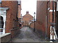
College Walk, Leicester
College Walk, an alley in Leicester.
Image: © Malc McDonald
Taken: 27 Feb 2011
0.06 miles
9
Freemasons' Hall, London Road, Leicester
Comprising what were originally two separate houses (nos 78 and 80), early 19th century, separately Listed Grade II.
Image: © Alan Murray-Rust
Taken: 26 Jan 2019
0.06 miles
10
Station Area, Leicester, LE2
Prebend Gardens are served by four sets of entrance gates. This picture was taken from inside the gate off Glebe Street. Prebend Gardens - and its centrally positioned wildlife pond - are situated within the South Highfield conservation area and were designed and established by the City Council in 1987 in conjunction with the City Wildlife Project and opened in the same year. In 2005 they were the subject of a regeneration project as the result of cooperation between the Council Parks Services and a number of local residents. College Street can be seen in the distance and Prebend Street lies to the right.
Image: © David Hallam-Jones
Taken: 5 May 2013
0.06 miles