IMAGES TAKEN NEAR TO
Brook Street, LEICESTER, LE19 4ND
Introduction
This page details the photographs taken nearby to Brook Street, LE19 4ND by members of the Geograph project.
The Geograph project started in 2005 with the aim of publishing, organising and preserving representative images for every square kilometre of Great Britain, Ireland and the Isle of Man.

There are currently over 7.5m images from over14,400 individuals and you can help contribute to the project by visiting https://www.geograph.org.uk
Image Map
Images are licensed for reuse under creativecommons.org/licenses/by-sa/2.0
Notes
- Clicking on the map will re-center to the selected point.
- The higher the marker number, the further away the image location is from the centre of the postcode.
Image Listing (19 Images Found)
Images are licensed for reuse under creativecommons.org/licenses/by-sa/2.0
Image
Details
Distance
1
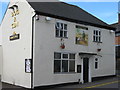
Enderby Dog & Gun
9 Cross Street. Marstons pub in village centre.
Image: © the bitterman
Taken: 28 Oct 2009
0.02 miles
2
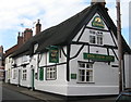
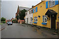
Enderby New Inn
51 High Street. Everards pub.
Image: © the bitterman
Taken: 28 Oct 2009
0.06 miles
3
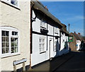
The New Inn along the High Street, Enderby
Image: © Mat Fascione
Taken: 24 Feb 2018
0.07 miles
4
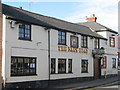
Enderby Nags Head
41 Cross Street. Locals pub in the heart of the village.
Image: © the bitterman
Taken: 28 Oct 2009
0.08 miles
5
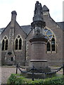
Statue of Charles Brook
Charles Brook was a philanthropist who purchased Enderby Hall in 1865.
The statue is outside the Old School.
Image: © Mat Fascione
Taken: 6 Jul 2014
0.09 miles
7
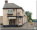
Conery Lane, Enderby
A grocery shop at the junction of Conery Lane with Mill Hill.
Image: © Terry Roberts
Taken: 11 Sep 2005
0.12 miles
8
Seine Lane, Enderby
Strawberry Gardens to left and the village straight ahead. The bridge crosses the northern end of Image
Image: © Kate Jewell
Taken: 12 May 2006
0.12 miles
9
After the rain on Chapel Street, Enderby
Croft View Cottage is a bright spot in an otherwise dismal post-thunder scene. The United Reformed Church, which gave this street its name, is just beyond.
Image: © Kate Jewell
Taken: 12 May 2006
0.12 miles
10
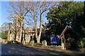
Enderby (St John the Baptist) Parish Church
An 'evangelical' Church of England https://www.enderbyparishchurch.org/ . The tower is 14th century, with the remainder rebuilt in the mid 19th century https://historicengland.org.uk/listing/the-list/list-entry/1361072?section=official-list-entry
Image: © Tim Heaton
Taken: 9 Dec 2022
0.13 miles