IMAGES TAKEN NEAR TO
Inver Road, LEICESTER, LE19 4DL
Introduction
This page details the photographs taken nearby to Inver Road, LE19 4DL by members of the Geograph project.
The Geograph project started in 2005 with the aim of publishing, organising and preserving representative images for every square kilometre of Great Britain, Ireland and the Isle of Man.

There are currently over 7.5m images from over14,400 individuals and you can help contribute to the project by visiting https://www.geograph.org.uk
Image Map (Loading...)


Getting Data...Please wait
Leaflet Map data © OpenStreetMap
Images are licensed for reuse under creativecommons.org/licenses/by-sa/2.0
Notes
- Clicking on the map will re-center to the selected point.
- The higher the marker number, the further away the image location is from the centre of the postcode.
Image Listing (64 Images Found)
Images are licensed for reuse under creativecommons.org/licenses/by-sa/2.0
Image
Details
Distance
1
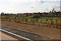
Almost finished
Enderby Drive is the last part of the New Lubbthorpe estate to be finished so far, this part is nearly done.
Image: © David Howard
Taken: 2 Jul 2023
0.06 miles
2
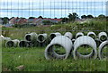
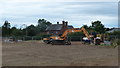
Construction work near Old Warren Farm
This is the northern edge of the New Lubbesthorpe housing development, 4,250 homes will be built on a site that lies to the west of the M1, east of Beggar’s Lane, south of Leicester Forest East and north and south of the M69.
The houses in the distance are part of a new housing estate called Forest Chase.
Image: © Mat Fascione
Taken: 15 Jul 2017
0.07 miles
3
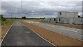
New road and cyclepath at New Lubbesthorpe
This is the site of the New Lubbesthorpe housing development, 4,250 homes will be built on a site that lies to the west of the M1, east of Beggar’s Lane, south of Leicester Forest East and north and south of the M69.
This road officially opened to traffic on July 13 2017.
Image: © Mat Fascione
Taken: 14 Jul 2017
0.07 miles
5
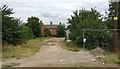
Old Warren Farm
This farm is on the northern edge of the New Lubbesthorpe housing development, it will soon be surrounded by new homes.
Image: © Mat Fascione
Taken: 14 Jul 2017
0.09 miles
6
Building site next to Old Warren Farm
This is the site of the New Lubbesthorpe housing development, 4,250 homes will be built on a site that lies to the west of the M1, east of Beggar’s Lane, south of Leicester Forest East and north and south of the M69.
Image: © Mat Fascione
Taken: 15 Jul 2017
0.09 miles

8

Houses under construction along Tay Road, New Lubbesthorpe
Image: © Mat Fascione
Taken: 20 Feb 2024
0.10 miles
10

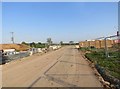
New road and cyclepath at New Lubbesthorpe
This is the site of the New Lubbesthorpe housing development, 4,250 homes will be built on a site that lies to the west of the M1, east of Beggar’s Lane, south of Leicester Forest East and north and south of the M69.
This road officially opened to traffic on July 13 2017.
Image, for a similar view taken over six months earlier.
Image: © Mat Fascione
Taken: 14 Jul 2017
0.12 miles