IMAGES TAKEN NEAR TO
Pimpernel Close, LEICESTER, LE19 3RZ
Introduction
This page details the photographs taken nearby to Pimpernel Close, LE19 3RZ by members of the Geograph project.
The Geograph project started in 2005 with the aim of publishing, organising and preserving representative images for every square kilometre of Great Britain, Ireland and the Isle of Man.

There are currently over 7.5m images from over14,400 individuals and you can help contribute to the project by visiting https://www.geograph.org.uk
Image Map
Images are licensed for reuse under creativecommons.org/licenses/by-sa/2.0
Notes
- Clicking on the map will re-center to the selected point.
- The higher the marker number, the further away the image location is from the centre of the postcode.
Image Listing (13 Images Found)
Images are licensed for reuse under creativecommons.org/licenses/by-sa/2.0
Image
Details
Distance
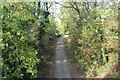
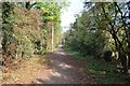
1
Whistle Way, Narborough
This walkway along a disused mineral railway line from Coventry Road, Narborough to Granite Close, Enderby gives good views to the River Soar. View point on the bridge in Image
Image: © Kate Jewell
Taken: 12 May 2006
0.05 miles
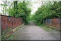
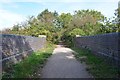
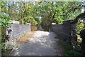
2
A bridge that once carried the Enderby Branch Railway
It now carries the Whistle Way foot and cycle path.
Image: © Tim Glover
Taken: 15 Jul 2016
0.05 miles
3
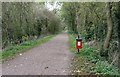
Whistle Way at Narborough
Public footpath and cycleway along an old railway line, running along the western edge of Narborough village.
Image: © Mat Fascione
Taken: 11 Oct 2017
0.08 miles
4
Former Railway
The dismantled railway line is now the Whistle Way footpath.
Image: © Ashley Dace
Taken: Unknown
0.09 miles
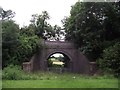
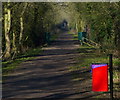
5
Former Quarry Line
An old railway bridge on Whistle Way.
Image: © Ashley Dace
Taken: Unknown
0.11 miles
7
Heading north along the Whistle Way at Narborough
Public footpath and cycleway along an old railway line, running along the western edge of Narborough village.
Image: © Mat Fascione
Taken: 24 Feb 2018
0.14 miles
9
Former Quarry Line
The former quarry line is now a cycle path.
Image: © Ashley Dace
Taken: Unknown
0.15 miles