IMAGES TAKEN NEAR TO
Lutterworth Road, LUTTERWORTH, LE17 6JF
Introduction
This page details the photographs taken nearby to Lutterworth Road, LE17 6JF by members of the Geograph project.
The Geograph project started in 2005 with the aim of publishing, organising and preserving representative images for every square kilometre of Great Britain, Ireland and the Isle of Man.

There are currently over 7.5m images from over14,400 individuals and you can help contribute to the project by visiting https://www.geograph.org.uk
Image Map
Images are licensed for reuse under creativecommons.org/licenses/by-sa/2.0
Notes
- Clicking on the map will re-center to the selected point.
- The higher the marker number, the further away the image location is from the centre of the postcode.
Image Listing (4 Images Found)
Images are licensed for reuse under creativecommons.org/licenses/by-sa/2.0
Image
Details
Distance
3
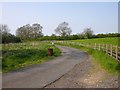
Walcote
The Lane bends sharply after crossing the stream and heads towards Middle Poultney Farm.
Image: © Ian Rob
Taken: 10 May 2006
0.23 miles
4
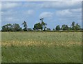
Farmland north of Lutterworth Road
The trees to the right are called The Belt and run along the northern side of Lutterworth Road.
Image: © Mat Fascione
Taken: 22 Jun 2008
0.23 miles