IMAGES TAKEN NEAR TO
Partridge Close, LUTTERWORTH, LE17 5QY
Introduction
This page details the photographs taken nearby to Partridge Close, LE17 5QY by members of the Geograph project.
The Geograph project started in 2005 with the aim of publishing, organising and preserving representative images for every square kilometre of Great Britain, Ireland and the Isle of Man.

There are currently over 7.5m images from over14,400 individuals and you can help contribute to the project by visiting https://www.geograph.org.uk
Image Map
Images are licensed for reuse under creativecommons.org/licenses/by-sa/2.0
Notes
- Clicking on the map will re-center to the selected point.
- The higher the marker number, the further away the image location is from the centre of the postcode.
Image Listing (7 Images Found)
Images are licensed for reuse under creativecommons.org/licenses/by-sa/2.0
Image
Details
Distance
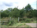
1
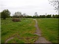
Upper Bruntingthorpe
An old point of access to the aerodrome leads from this small housing estate.
Image: © Ian Rob
Taken: 2 May 2006
0.08 miles
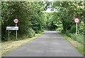
2
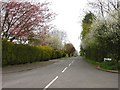
Upper Bruntingthorpe
Churchill Drive at its junction with Mere Road.
Image: © Ian Rob
Taken: 2 May 2006
0.11 miles
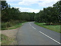
3
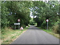
Entering Upper Bruntingthorpe village
South east on Mere Road.
Image: © JThomas
Taken: 9 Aug 2014
0.16 miles
4
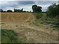
Stubble field west of Walton New Road, Upper Bruntingthorpe
Image: © JThomas
Taken: 9 Aug 2014
0.20 miles
7
Walton New Road, Upper Bruntingthorpe
Heading north.
Image: © JThomas
Taken: 9 Aug 2014
0.24 miles