IMAGES TAKEN NEAR TO
Main Street, LUTTERWORTH, LE17 5JH
Introduction
This page details the photographs taken nearby to Main Street, LE17 5JH by members of the Geograph project.
The Geograph project started in 2005 with the aim of publishing, organising and preserving representative images for every square kilometre of Great Britain, Ireland and the Isle of Man.

There are currently over 7.5m images from over14,400 individuals and you can help contribute to the project by visiting https://www.geograph.org.uk
Image Map
Images are licensed for reuse under creativecommons.org/licenses/by-sa/2.0
Notes
- Clicking on the map will re-center to the selected point.
- The higher the marker number, the further away the image location is from the centre of the postcode.
Image Listing (18 Images Found)
Images are licensed for reuse under creativecommons.org/licenses/by-sa/2.0
Image
Details
Distance
1
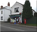
Dunton Bassett Post Office & Newsagents
The building is called Birmingham House and located along Main Street.
Image: © Mat Fascione
Taken: 24 Feb 2008
0.02 miles
2

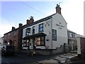
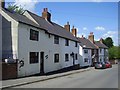
Dunton Bassett Arms
9 Bennetts Hill. Called the Shoulder of Mutton until 1988.
Image: © the bitterman
Taken: 15 May 2011
0.03 miles
4
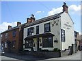
The Dunton Bassett Arms
Public House on Bennett's Hill, which is also a Chinese Restaurant.
Image: © Ian Rob
Taken: 31 May 2011
0.04 miles
6
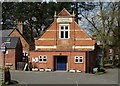
Dunton Bassett village hall
At the corner of The Mount and Bennetts Hill.
Image: © Mat Fascione
Taken: 24 Feb 2008
0.08 miles
8
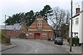
Dunton Bassett-The Mount
Cottages near the school.
Image: © Ian Rob
Taken: 31 May 2011
0.11 miles
9
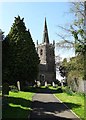
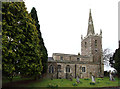
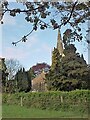
All Saints - Dunton Bassett's parish church
Image: © Neil Theasby
Taken: 14 Apr 2014
0.11 miles