IMAGES TAKEN NEAR TO
Watling Street, LUTTERWORTH, LE17 5BE
Introduction
This page details the photographs taken nearby to Watling Street, LE17 5BE by members of the Geograph project.
The Geograph project started in 2005 with the aim of publishing, organising and preserving representative images for every square kilometre of Great Britain, Ireland and the Isle of Man.

There are currently over 7.5m images from over14,400 individuals and you can help contribute to the project by visiting https://www.geograph.org.uk
Image Map
Images are licensed for reuse under creativecommons.org/licenses/by-sa/2.0
Notes
- Clicking on the map will re-center to the selected point.
- The higher the marker number, the further away the image location is from the centre of the postcode.
Image Listing (11 Images Found)
Images are licensed for reuse under creativecommons.org/licenses/by-sa/2.0
Image
Details
Distance
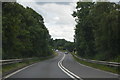
3
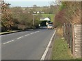
A5 Watling Street towards Wibtoft
Following the course of a former Roman Road, this forms the border between Leicestershire and Warwickshire.
Image: © Mat Fascione
Taken: 23 Nov 2007
0.02 miles
4
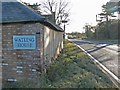
Watling House in Wibtoft
The former Roman Road and current A5 Watling Street passes through the centre of the small village of Wibtoft, on the border of Leicestershire and Warwickshire.
Image: © Mat Fascione
Taken: 23 Nov 2007
0.08 miles
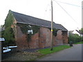
5
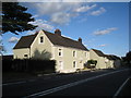
Alma House near Wiboft
Although only separated by Watling Street from Wibtoft in Warwickshire, Alma House is in the parish of Claybrooke Parva in Leicestershire.
Image: © Jonathan Thacker
Taken: 29 Aug 2010
0.12 miles
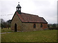
7
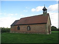
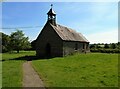
St. Mary, Wibtoft
The churchyard is completely devoid of gravestones and has a peculiarly arid feel.
Image: © Jonathan Thacker
Taken: 29 Aug 2010
0.16 miles
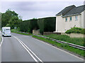
8
Green Lane, Wibtoft
This small village is on the border of Warwickshire and Leicestershire, although most of the village lies with Warwickshire. The A5 Watling Street is close by.
Image: © Mat Fascione
Taken: 23 Nov 2007
0.19 miles