IMAGES TAKEN NEAR TO
Longhold Road, MARKET HARBOROUGH, LE16 9RF
Introduction
This page details the photographs taken nearby to Longhold Road, LE16 9RF by members of the Geograph project.
The Geograph project started in 2005 with the aim of publishing, organising and preserving representative images for every square kilometre of Great Britain, Ireland and the Isle of Man.

There are currently over 7.5m images from over14,400 individuals and you can help contribute to the project by visiting https://www.geograph.org.uk
Image Map
Images are licensed for reuse under creativecommons.org/licenses/by-sa/2.0
Notes
- Clicking on the map will re-center to the selected point.
- The higher the marker number, the further away the image location is from the centre of the postcode.
Image Listing (1 Images Found)
Images are licensed for reuse under creativecommons.org/licenses/by-sa/2.0
Image
Details
Distance
1
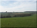
View to Farm Development and Beyond.
View across open farmland towards Long Hold Spinney (top right) and Naseby Covert (just visible top left). There are no footpaths in this area.
Image: © Richard Williams
Taken: 4 Feb 2007
0.01 miles