IMAGES TAKEN NEAR TO
High Street West, OAKHAM, LE15 9QE
Introduction
This page details the photographs taken nearby to High Street West, LE15 9QE by members of the Geograph project.
The Geograph project started in 2005 with the aim of publishing, organising and preserving representative images for every square kilometre of Great Britain, Ireland and the Isle of Man.

There are currently over 7.5m images from over14,400 individuals and you can help contribute to the project by visiting https://www.geograph.org.uk
Image Map (Loading...)


Getting Data...Please wait
Leaflet Map data © OpenStreetMap
Images are licensed for reuse under creativecommons.org/licenses/by-sa/2.0
Notes
- Clicking on the map will re-center to the selected point.
- The higher the marker number, the further away the image location is from the centre of the postcode.
Image Listing (267 Images Found)
Images are licensed for reuse under creativecommons.org/licenses/by-sa/2.0
Image
Details
Distance
1
![Uppingham School [1]](https://s3.geograph.org.uk/geophotos/07/14/55/7145599_3af29833_120x120.jpg)
Uppingham School [1]
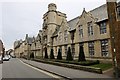
The buildings of Uppingham School dominate the southern side of High Street West. Seen here is the science block and tower built in 1897 and extended in the early 20th century. Constructed of coursed rubble stone under a slate roof. In Jacobean style, a central tower with wing on both sides. Listed, grade II, with details at:
https://historicengland.org.uk/listing/the-list/list-entry/1073178
Uppingham School is an independent, co-educational, fee charging school for boarders aged 13 to 18, founded in 1584.
Uppingham is a market town in the county of Rutland, and received its charter in 1281. It is located near the border with Northamptonshire, approximately 17 miles east of Leicester and some 20 miles west of Peterborough. The A47 road ran through the town until a bypass was built in 1982.
Image: © Michael Dibb
Taken: 28 Sep 2021
0.01 miles
2
![Uppingham School [5]](https://s3.geograph.org.uk/geophotos/07/14/56/7145603_4b60db62_120x120.jpg)
Uppingham School [5]
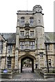
These fine gates and gate piers lead into the school from High Street West.
Uppingham School is an independent, co-educational, fee charging school for boarders aged 13 to 18, founded in 1584.
Uppingham is a market town in the county of Rutland, and received its charter in 1281. It is located near the border with Northamptonshire, approximately 17 miles east of Leicester and some 20 miles west of Peterborough. The A47 road ran through the town until a bypass was built in 1982.
Image: © Michael Dibb
Taken: 28 Sep 2021
0.01 miles
3
Uppingham School Victoria Science Block
Grade II listed. Listing number 1073178. Science block and tower, 1897 and early C20. Of coursed rubble with slate roof and massive ridge stack. Jacobean style.
Image: © Andrew Abbott
Taken: 20 Aug 2017
0.01 miles
4
Victoria Block Tower
At Uppingham School. Dated 1897 and early C20.
Image: © Andrew Abbott
Taken: 20 Aug 2017
0.01 miles
5
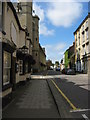
High Street West, Uppingham
The large stone building with its distinctive towers on the left is Uppingham School. The school owns many old buildings in this part of the town.
Image: © Kate Jewell
Taken: 29 Aug 2005
0.02 miles
6
![Uppingham houses [11]](https://s0.geograph.org.uk/geophotos/07/14/55/7145592_5b70a85e_120x120.jpg)
Uppingham houses [11]
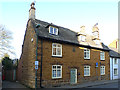
Number 28 High Street West is dated 1787. Constructed of coursed Ironstone rubble stone under a Collyweston stone slate roof. There is a rear extension in red brick. Listed, grade II, with details at: https://historicengland.org.uk/listing/the-list/list-entry/1178286
Uppingham is a market town in the county of Rutland, and received its charter in 1281. It is located near the border with Northamptonshire, approximately 17 miles east of Leicester and some 20 miles west of Peterborough. The A47 road ran through the town until a bypass was built in 1982. The town is home to Uppingham School, an independent, co-educational, fee charging school for boarders aged 13 to 18, founded in 1584.
Image: © Michael Dibb
Taken: 28 Sep 2021
0.02 miles
7
![Uppingham houses [10]](https://s3.geograph.org.uk/geophotos/07/14/55/7145591_a6f1261b_120x120.jpg)
Uppingham houses [10]
Number 26 High Street West is a much restored house originally built in, probably, the 17th century. Constructed or rendered and painted stone under a Welsh slate roof. Listed, grade II, with details at: https://historicengland.org.uk/listing/the-list/list-entry/1073966
Uppingham is a market town in the county of Rutland, and received its charter in 1281. It is located near the border with Northamptonshire, approximately 17 miles east of Leicester and some 20 miles west of Peterborough. The A47 road ran through the town until a bypass was built in 1982. The town is home to Uppingham School, an independent, co-educational, fee charging school for boarders aged 13 to 18, founded in 1584.
Image: © Michael Dibb
Taken: 28 Sep 2021
0.02 miles
8
House in High Street West, Uppingham
This is the house, opposite the gates of Uppingham School, where I lived until I was 11. At that time 1936-1947 (if not now), the front part of the ground floor was occupied by a solicitors office. Access to our house was through the gate into the garden on the left hand side.
Image: © Oliver Dixon
Taken: 9 Mar 2014
0.02 miles
9
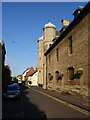
High Street West in Uppingham
An outside wall of Uppingham School dominates the town's narrow High Street West. Grander façades are to be seen around the corner just beyond the two towers (see Image).
Image: © Kevin Flynn
Taken: 29 May 2007
0.02 miles
10
![Uppingham School [2]](https://s0.geograph.org.uk/geophotos/07/14/56/7145600_065ad00f_120x120.jpg)
Uppingham School [2]
The buildings of Uppingham School dominate the southern side of High Street West. Seen here is part of the block forms one side of the quadrangle. Built in 1863 in the Gothic Revival style. Constructed of squared, coursed rubble stone with ashlar dressings under a slate roof. Listed, grade II, with details at:
https://historicengland.org.uk/listing/the-list/list-entry/1073176
Uppingham School is an independent, co-educational, fee charging school for boarders aged 13 to 18, founded in 1584.
Uppingham is a market town in the county of Rutland, and received its charter in 1281. It is located near the border with Northamptonshire, approximately 17 miles east of Leicester and some 20 miles west of Peterborough. The A47 road ran through the town until a bypass was built in 1982.
Image: © Michael Dibb
Taken: 28 Sep 2021
0.03 miles