IMAGES TAKEN NEAR TO
Middle Street, OAKHAM, LE15 8RZ
Introduction
This page details the photographs taken nearby to Middle Street, LE15 8RZ by members of the Geograph project.
The Geograph project started in 2005 with the aim of publishing, organising and preserving representative images for every square kilometre of Great Britain, Ireland and the Isle of Man.

There are currently over 7.5m images from over14,400 individuals and you can help contribute to the project by visiting https://www.geograph.org.uk
Image Map
Images are licensed for reuse under creativecommons.org/licenses/by-sa/2.0
Notes
- Clicking on the map will re-center to the selected point.
- The higher the marker number, the further away the image location is from the centre of the postcode.
Image Listing (79 Images Found)
Images are licensed for reuse under creativecommons.org/licenses/by-sa/2.0
Image
Details
Distance
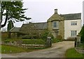
1
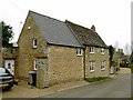
7 Middle Street, Wing and attached barn
The house is the further part of the building and is dated 1771 http://www.geograph.org.uk/photo/4853149, coursed stone rubble with Collyweston stone slate roof, Listed Grade II. The barn extension is probably slightly later.
Image: © Alan Murray-Rust
Taken: 29 Feb 2016
0.00 miles
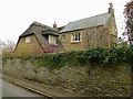
2
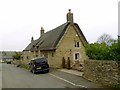
8 Middle Street, Wing
Thatched cottage in coursed stone rubble, probably dating from the early 17th century. Listed Grade II.
Image: © Alan Murray-Rust
Taken: 29 Feb 2016
0.01 miles
3
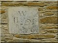
Datestone, 7 Middle Street, Wing
Dated 1771. See http://www.geograph.org.uk/photo/4853148 for location.
Image: © Alan Murray-Rust
Taken: 29 Feb 2016
0.01 miles
4
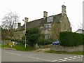
15 & 17 Middle Street, Wing
Probably mid-18th century, but not built together. (There is a join between the two sections, not visible in the picture.) Coursed stone rubble with Collyweston stone slate roof, Listed Grade II.
Image: © Alan Murray-Rust
Taken: 29 Feb 2016
0.02 miles
5
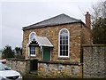
Stable Cottage, Middle Street, Wing
18th century cottage with attached barn, Listed Grade II. The house at the rear is not included in the listing description.
Image: © Alan Murray-Rust
Taken: 29 Feb 2016
0.03 miles
7
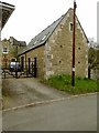
Former Methodist Chapel, Middle Street, Wing
Built around 1840, now converted to residential use. The porch in 'tin tabernacle' style is later but not modern. coursed stone rubble with Welsh slate roof, Listed Grade II.
Image: © Alan Murray-Rust
Taken: 29 Feb 2016
0.03 miles
8
7 The Jetty, Wing
Small house, built in two stages, the earlier probably dating from the 17th century, coursed stone rubble with Welsh slate roof, Listed Grade II.
Image: © Alan Murray-Rust
Taken: 29 Feb 2016
0.05 miles
9
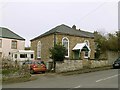
Cedar House, Bottom Street, Wing
A rather heterogeneous house, of 18th century origin, with Victorian overtones. Listed Grade II.
Image: © Alan Murray-Rust
Taken: 29 Feb 2016
0.05 miles
10
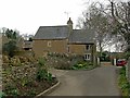
Garden Cottage, Top Street, Wing
The thatched section is dated 1668, the slate roofed wing being a 19th century extension. Listed Grade II.
Image: © Alan Murray-Rust
Taken: 29 Feb 2016
0.05 miles